
SERVIR Applied Sciences Team results helping endangered great apes in Africa
When forested areas are connected to one another, they form pathways essential to wildlife that need to move from one habitat to another in search of food, nesting sites, water, and mates. However, forest loss and fragmentation due to human activities like agriculture and commercial logging can eliminate these biological corridors, imperiling populations of many species, some of which are already threatened or endangered.
Many forested protected areas in eastern and western Africa are isolated from one another by fields, farms, villages, and cities. In addition, new infrastructure (roads, etc.) and expanding agricultural land use are now advancing upon protected areas that are still connected to one another by intact forests. And the already endangered – some critically endangered and nearing extinction* -- species of great apes are among the most vulnerable to these pressures.
 |
| Photo credit: Patrick Cyusa / Wikimedia Commons / Public Domain |
Results of a SERVIR Applied Sciences Team (AST) project are helping to identify areas where forest protection and reforestation will help these magnificent animals.
Last year, AST members Patrick Jantz, Scott Goetz, and Nadine Laporte used high-resolution vegetation carbon stock data derived from NASA satellite sensors to map forest corridors across the tropics. Their aim was to support East African countries participating in an important conservation initiative called REDD+, which provides funds for tropical countries in proportion to their efforts to protect forests and reduce greenhouse gas emissions, particularly CO2. Countries that have engaged with REDD+ need accurate information about their forests' extents and concentrations in order to assess their carbon stores and develop forest conservation strategies. The maps produced by Jantz and his colleagues revealed that many biological corridors are as rich or richer in carbon and forests as the protected areas they connect.
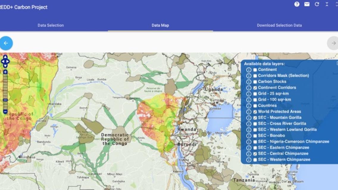
Now these maps are being used by the United Nations’ Great Apes Survival Project (GRASP)-REDD+ project to show potential biological corridors (between reserves) that could both serve as forest protection areas and improve connectivity for ape populations. The GRASP-REDD+ project’s online tool superimposes the maps on great ape distribution maps of Africa and Asia to help decision-makers, climate specialists, and conservation organizations identify priority areas for implementing REDD projects to protect forests while also considering great apes conservation.
 |
| Screenshot of online tool showing protected areas with great ape populations connected via high biomass corridors. Click here to go to the tool. |
“We intentionally freely distribute our datasets and maps, and we’re quite glad to see them being used in this way,” says Jantz. “We are now in the process of supporting the creation of forest corridors in the Murchison-Semliki Landscape to conserve eastern chimpanzee populations and looking at possible incentives such as funding through REDD+ to encourage farmers to conserve forest on their land.”
Notes
- *Three of the four species of gorillas in Africa are critically endangered, with the fourth species now nearing the critical level.
- REDD+ stands for Reducing carbon Emissions resulting from Deforestation and forest Degradation. Forested areas are important to our planet's health because they take in large amounts of carbon and release oxygen, helping to supply clean water and air. It is important to preserve carbon stored in vegetation. When forests are removed or degraded, less carbon is taken from the atmosphere, and the result is increased carbon emissions – which is known to hasten climate change and increase its impact. Primarily for these reasons, REDD+ seeks to protect the Earth's forests.
- GRASP and UN-REDD worked with the Max Planck Institute for Evolutionary Anthropology to develop their on-line tool, which can be accessed at the link below. Clicking on the information button next to the Selection Model heading pops up a window that provides a link to the Jantz et al corridor datasets/maps. http://primatdbext.eva.mpg.de/redd/
- The corridor dataset/ maps can also be found here: https://www.arcgis.com/home/item.html?id=1ffd5425e88f46af856c1f44cc732a7d
- See this article for more information on the work of Jantz, Goetz, and Laporte: Jantz, P., S.J. Goetz and N.T. Laporte. Carbon stock corridors to mitigate climate change and promote biodiversity in the tropics. 2014. Nature Climate Change, http://dx.doi.org/10.1038/NCLIMATE2105. The work was made possible through the support of the NASA Applied Sciences program, the Gordon and Betty Moore Foundation, the Packard Foundation, and the Google.org Foundation.
- The AST members, with the Regional Centre for Mapping of Resources for Development (RCMRD) -- the SERVIR-Eastern and Southern Africa hub institution, have hosted several training workshops in Africa to equip forestry technicians and geospatial analysts with tools and skills to monitor and document the extent of forests and where they are changing as a result of deforestation and forest degradation. In some of the workshops, open source scripts for conducting corridor mapping were presented.
