
Monitoring the mighty Mekong River's water quality from space
The Mekong River is a trans-boundary river system originating in Tibet and spanning China and five countries in Southeast Asia. It is Asia’s third largest river in terms of length and sediment load1. About 60 million people depend on this river for their livelihoods; however, the Mekong’s water quality is degrading due to pollution driven by population increase, economic development, deforestation, and intensified weather events2,3. Rapid industrial and agricultural development along with construction of dams in the region have and will continue to alter the river’s flow and sediment load as well as the landscape within the region4. To understand these changes and their impact on the river’s water quality, it is important to monitor the amount of suspended sediment – a key indicator of water quality -- in the river at various locations via in situ collections and visible satellite imagery.
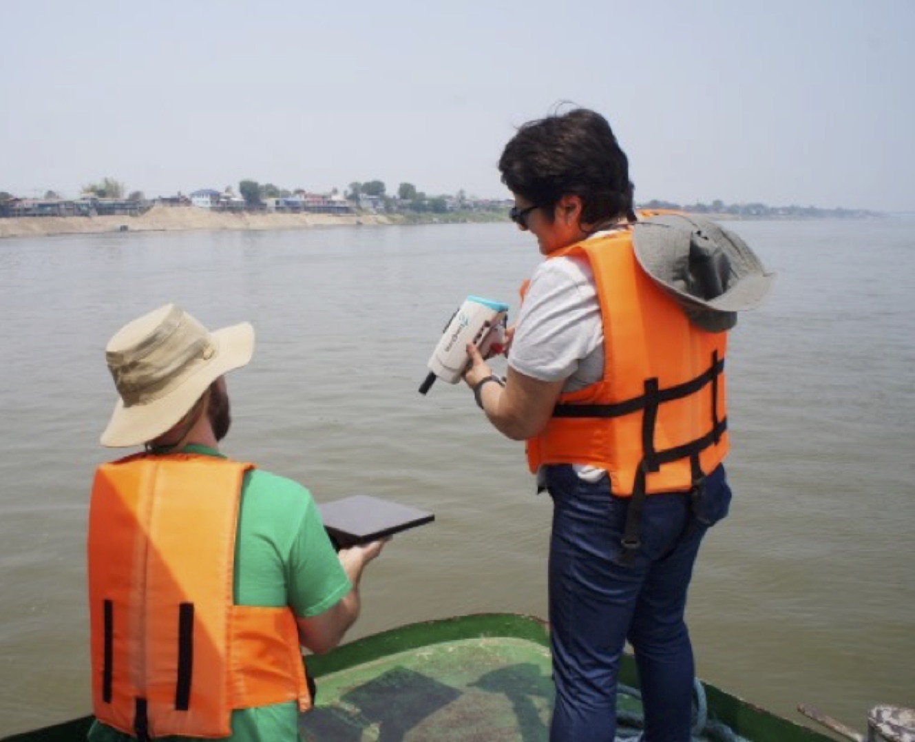 |
| Dr. Sonia Gallegos (right) collecting radiometer data to calibrate the sensor on a gray card held by Kel Markert (left) on the Mekong River near Mukdahan, Thailand. Credits: Dr. Sarunya Promkotra, Khon Kaen University. |
While these data are accessible via remote sensing sensors such as the Moderate Resolution Imaging Spectroradiometer (MODIS) on a daily basis, the coarse spatial resolution (~1km) of this product limits its usefulness to wider portions of the river and its tributaries. Moreover, MODIS water quality products, developed for ocean and coastal waters, are not accurate for riverine environments where the concentration of in-water components such as phytoplankton and suspended sediment is many times higher than in ocean and coastal waters. Data from the Landsat 8 Operational Land Imager (OLI) is ideal for development of riverine algorithms because of its 30-m resolution and a new blue spectral band (not present in previous Landsat sensors) specifically designed for remote sensing water resources and coastal applications.
To monitor the degradation of the Mekong River, SERVIR partnered with Dr. Sonia Gallegos of the Naval Research Laboratory to develop a suspended sediment monitoring tool for the Landsat 8 OLI. This tool processes the OLI data to calculate the amount of sunlight being reflected from the water using the SeaDAS computer software application from NASA/Goddard. The reflectance data is then used to calculate the sediment concentration within the river and create maps. Importantly, the tool can accommodate future sediment algorithms and refinements that are likely with the acquisition of new in situ measurements.
As part of the research, Dr. Gallegos and Mr. Kel Markert, a SERVIR graduate research assistant from the University of Alabama in Huntsville, traveled to Thailand to collect field samples that will help calibrate the OLI sensor and validate the suspended sediment algorithm for the Mekong River. The suspended sediment algorithm product will be transitioned to the SERVIR-Mekong hub at the Asian Disaster Preparedness Center (ADPC) in Bangkok, Thailand. SERVIR-Mekong will use this tool to supply critical information on the location and timing of water quality degradation within the Mekong River.
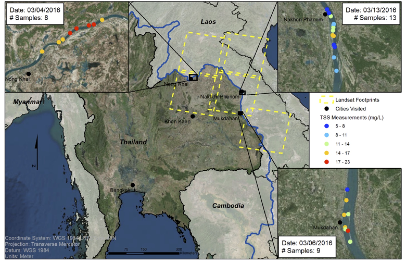
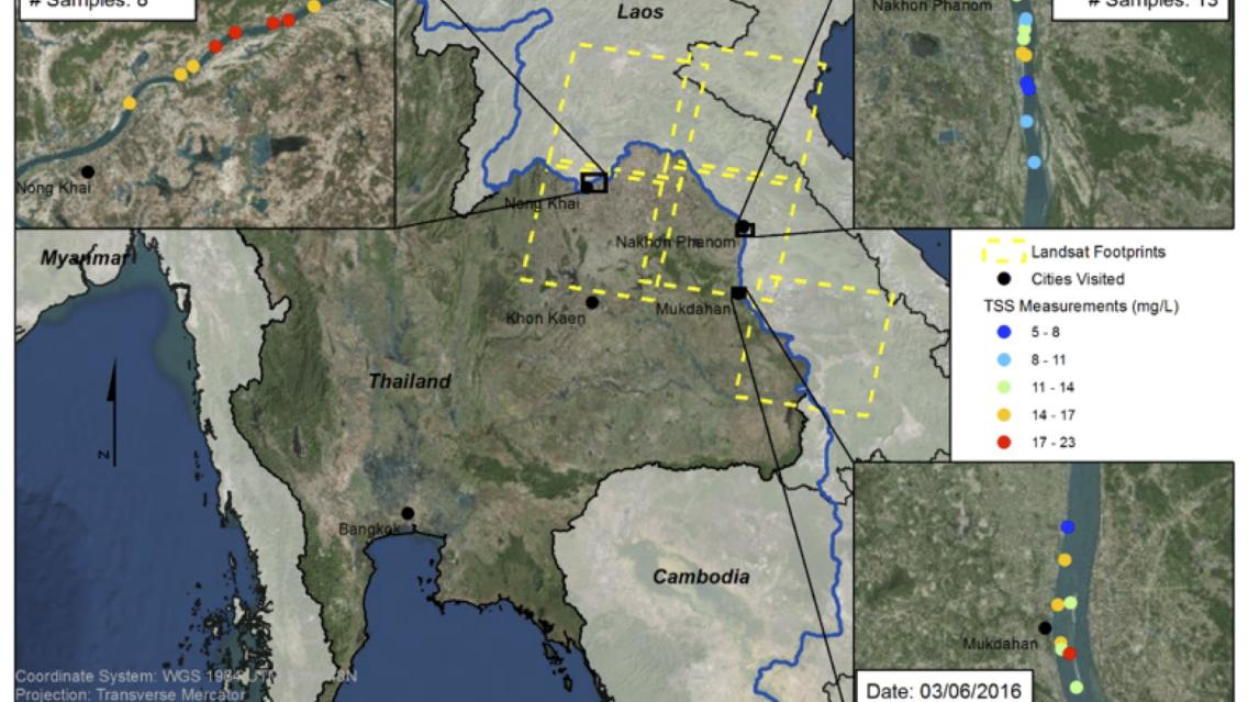
Map of field collection sites and total suspended solid measurements along
the Mekong River. Credits: NASA/SERVIR
The collections took place in the Mekong River off the ports of Nong Khai, Nakhon Phanom, and Mukdahan in Thailand. Data collections--which coincided with three different Landsat 8 overpass dates-- included water samples, radiometric measurements of the water and sky, air and water temperature, and light attenuation at 31 different stations.
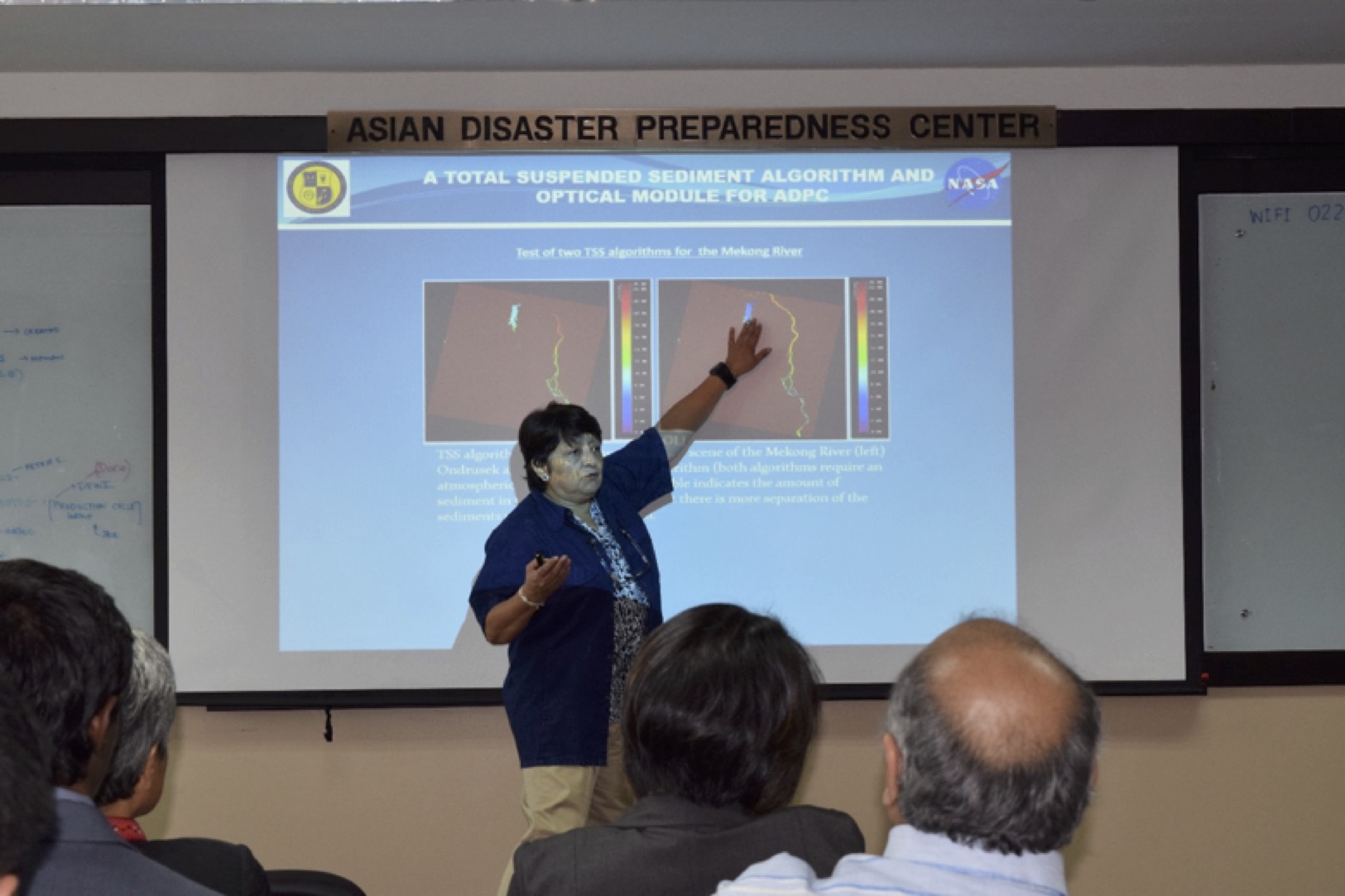 |
| Dr. Gallegos presenting results of the suspended sediment algorithm to ADPC and other academic and governmental institutions at the research seminar concluding the field trip on 18 March 2016. Credit: ADPC |
Following the field work, Dr. Gallegos and Mr. Markert met with the SERVIR-Mekong team to discuss transferring the sediment monitoring product to the hub. They also presented results to date in a research seminar to ADPC and an audience of other academic and government institutions from Thailand.
This research trip provided an opportunity to establish collaborations with researchers and water resources managers in the Lower Mekong region who will be able to access and interpret these Landsat-derived products on freshwater quality.
References:
- Milliman, J.D., and Meade R.H. (1983), World-wide delivery of river sediment to the oceans, J. Geol., 91, 1-21
- Olsen, D.M., and Dinerstein, E. (2002), The global 200: priority ecoregions for global conservation, Ann. Mo. Bat. Gard., 89, 199-224
- Dudgeon, D. (2005), River rehabilitation for conservation of fish biodiversity in monsoonal Asia, Ecol. Soc., 10, 15
- Le, T.V.H. et al. (2007), The combined impact on the flooding in Vietnam’s Mekong River delta of local man-made structures, sea level rise, and dams upstream in the river catchment, Estuar. Coast Shelf S., 71, 110-116
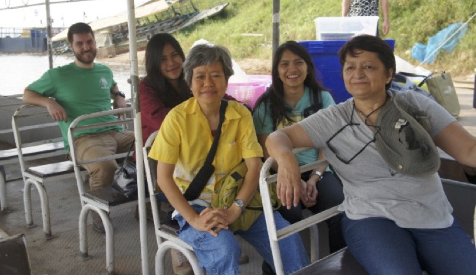 |
| Markert, Titinun Phungern, Dr. Promkotra, Tanyamas Siangvhan, and Dr. Gallegos (from left to right) preparing to collect water samples along the Mekong River. Credits: Dr. Sarunya Promkotra, Khon Kaen University. |
Note:
The field collections were made possible through a collaboration with Dr. Sarunya Promkotra of Khon Kaen University. She facilitated access to the boats and bridged the language barrier of coordinating with local residents and boat operators. She also provided the sampling team with laboratory space and support from two students. In addition, she analyzed the CDOM (colored dissolved organic matter) data, which was not planned for this effort. Dr. Gallegos and Mr. Markert are greatly indebted to Dr. Promkotra and Khon Kaen University of Thailand for their efforts on behalf of this research.