
FAO and SERVIR Helping to keep Sharper Eye on Forests and Land Use around the world
According to the World Wildlife Fund, over 2 billion people rely on forests for shelter, livelihoods, water, food, and fuel security. Forests even help renew our air supply, as they take in large amounts of carbon dioxide and release oxygen. They also provide habitat for wildlife, help protect watersheds, reduce soil erosion, and mitigate climate change. For all of these reasons, it is essential to have accurate and up-to-date information on the extent of the world’s forests and the ways they are changing. Tracking forest loss and land cover change over time has never been more important.
United Nations Food and Agriculture Organization (FAO) has been collecting data and reporting on the Earth’s forests for more than 65 years. Through their global Forest Resources Assessment (FRA), FAO collects and analyzes data that countries supply to them on a number of forest-related variables, and reports its results every five years. FAO also delivers data and statistics on agriculture, fisheries, and soil in those countries, focusing on land use properties and trends. For their land cover and land use assessments, FAO relies on remote sensing data from Earth observation satellites in addition to the data furnished by the countries.


ICIMOD participants during plot assessment
SERVIR hubs across the globe are helping the FAO conduct a new pilot assessment of tree cover, forest, and land use. The assessment is being conducted to test new, innovative tools and methodologies to complement traditional FRA information that is based on data reported by countries. The initiative seeks to demonstrate that global and regional trends in tree cover, forest, and land use can be evaluated more efficiently by using the new tools and methods to collect and analyze an ever increasing, ever improving compendium of remote sensing data.
 |
| From left, counterclockwise: Lawrence Okello, SERVIR-E&SA Remote Sensing Expert; Sarah Kerosi, FAO Project Consultant; Pamphil Ofisi, FAO Project Consultant; Justus Wambayi-UN FAO-Ke, Erastus Weru Ndirangu, RCMRD IT Technician, during training at RCMRD |
The assessment, which includes more than 500,000 sites around the world, is based on the use of two new tools: the FAO’s Open Foris Collect Earth software (http://www.openforis.org/tools/collect-earth.html) and the Google Earth Engine platform (https://earthengine.google.com/ ). Combining these new tools enables efficient sample-based visual assessment of trees, forest, and land use trends with simultaneous access to various key remote sensing data sources. The assessment is conducted through visual interpretation of very high and high-resolution Earth observation satellite images from publicly available repositories (such as Google Earth, Google Earth Engine, and Bing Maps). The results will be reported at the global and regional levels as well as at the November 2016 UN Framework Convention on Climate Change (UNFCC) Conference of Parties (COP-22) to be held in Marrakesh, Morocco.
Drawn from institutions worldwide, more than 400 experts with knowledge of land cover and land uses in specific regions are participating in the assessment. The institutions include the Regional Centre for Mapping of Resources for Development (RCMRD) in Kenya; the International Centre for Integrated Mountain Development (ICIMOD) in Nepal; and the Asian Disaster Preparedness Center (ADPC) in Thailand, all of which host SERVIR hubs. Other institutions involved include Natural Resources Management Field of Study, School of Environment, Resources, and Development, Asian Institute of Technology; Remote Sensing and Geographic Information System Field of Study, School of Engineering and Technology, Asian Institute of Technology; the European Commission Joint Research Centre; Austria’s International Institute for Applied Systems Analysis; the World Resource Institute; and a number of universities, research organizations, and governmental and non-governmental entities from various countries.
 |
| From L to R: Ms. Asamaporn Sitthi, Lecturer in Geography, Kasetsart University; Mr. Chudech Losiri, Lecturer in Geography, Srinakharinwirot University; Dr. Kanchana Nakhapakorn, Assistant Professor, Mahidol University; during the Mekong training |
“SERVIR’s contact with FAO started last year in a workshop organized by Land Cover for Climate [LC4C] in Uganda, in which the USGS [United States Geological Survey] provided an introductory explanation of Collect Earth,” explains Africa Flores of SERVIR’s Science Coordination Office (SCO), based at NASA’s Marshall Space Flight Center in Huntsville, Alabama. “Given the interest of RCMRD to learn more about Collect Earth and its additional software, the SCO contacted FAO-Italy (the developers) regarding training for the SERVIR network. FAO was very willing to provide the training, which was attended by SERVIR team members from RCMRD and the SCO. After the training, FAO contacted RCMRD to support the pilot study. Now RCMRD, ICIMOD, and ADPC are all working with FAO in this global initiative.”
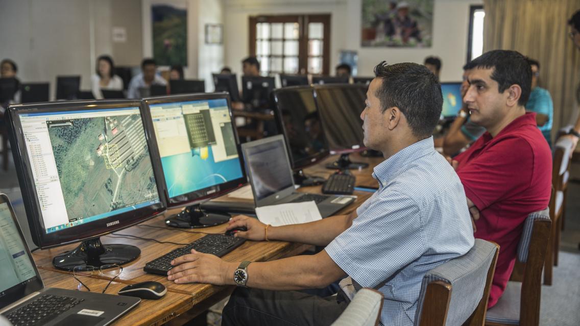
The assessment is conducted in a series of regionally focused training and data-collection workshops, organized in collaboration with all of the implementing partners. In the first week of each workshop, participants are trained by FAO experts in the use of Collect Earth. After this training, the participants spend several days collecting data for pre-defined sample sites. The purpose of this approach is to ensure that the interpretation is done consistently in all regions while also benefiting from the regional and local knowledge of participants.
FAO and RCMRD collaborated in Forest Assessment Training and Validation Workshops from 9-26 August 2016 in Nairobi, Kenya. FAO provided the training, and RCMRD provided guidance, supervision, and facilities to enable a selected group of participants to attend this short course on Collect Earth tools and to collect and analyze data with Saiku (a statistical analysis tool) for about 14,200 plots of land in the Eastern Africa region. Similar training took place in ICIMOD in Kathmandu, Nepal, 25 July to 5 August 2016, and they finished the collection of 15,249 sample sites. ADPC held a training and data collection campaign in Bangkok, Thailand, from September 12-16.
"The participants found Collect Earth relatively easy to use for a remote sensing tool with many advanced functions,” noted Adam Gerrand of FAO. “Some of the more challenging parts of the work were getting a better understanding of forest land-use as being something different from tree-cover that you see in satellite images. Once they had grasped that from applying the concepts in practice and asking questions, they made good progress."
 |
| From L to R: Dr. Walaiporn Phonphan, Lecturer, Suansanandha Rajabhat University; Ms. Chomchanok Arunplod, Lecturer in Geography, Srinakharinwirot University during the Mekong training |
Workshop participants were asked what actions they would undertake as a result of attending the Collect Earth workshop. Some of the answers they gave are listed below:
“use the tool in land use change analysis”
“apply this method/ software to deeply analyze/ monitor forest cover/ land use in our province”
“implement [what I learned in] the workshop to check NFI [National Forest Inventory] plots … in my working area”
“introduce the Collect Earth method to my colleagues in the district office [so they can begin] using it too”
“use it for monitoring land use and land cover of the plot of my province”
“report to my institution and share the knowledge to my office colleagues by presenting it and training other people to use Google Earth Engine”
Giulio Marchi, a Forestry Officer in FAO’s Forestry Department, said: “This assessment will contribute to improve knowledge of global and regional trends in trees, forests and other land uses, and the data generated can support activities of the Intergovernmental Panel on Climate Change, the United Nations Convention to Combat Desertification, the Convention on Biological Diversity, and the United Nations Development Programme Sustainable Development Goals. The contributions and assistance from staff and experts of SERVIR hubs has been essential to successfully completing the global assessment and it was greatly appreciated.”
 |
| Mr.Bhoj Raj Ghimire, a Doctoral Student at AIT and volunteer at the workshop, helps the participants during the Mekong workshop |
Gerrand agreed: “We really appreciated the excellent collaboration with SERVIR,” he said. “We also really value the continued and hopefully growing collaboration on the software itself.”
Notes:
Collect Earth is a tool in the Open Foris suite of free, open-source software tools developed by the FAO Forestry Department to facilitate flexible and efficient data collection, analysis and reporting. It was developed in cooperation with Google Earth Outreach (https://earthengine.google.com/case_studies) and its front-end interface operates inside Google Earth (Standard or Pro). Collect Earth functions in geosynchronization with Google Earth Engine to facilitate access to freely available satellite images from Earth Engine, and it can also connect to other services, such as Bing Maps and Yandex. By submitting pre-programmed scripts to Google Earth Engine Code Editor, Collect Earth can visualize reflectance values and user-defined indices such as the Normalized Difference Vegetation Index (NDVI), the Normalized Difference Water Index (NDWI) and the Enhanced Vegetation Index (EVI) based on Landsat and MODIS satellite images. The script can also show additional satellite images such as Sentinel 2 and processed products such as Landsat pan-sharpened images. Collect Earth enables operators to visually assess pre-defined sample locations and to store the results directly in a database by completing an onscreen data-collection form in Google Earth. Data can then be analysed with SAIKU, another free and open source software for business intelligence (http://www.meteorite.bi) or exported in common formats for further elaboration.
Phoebe Odour of SERVIR-E&SA/RCMRD interviews James Daniel,
a GIS Analyst from the World Agroforestry Center (ICRAF)
-
Collect Earth Online (CEO)
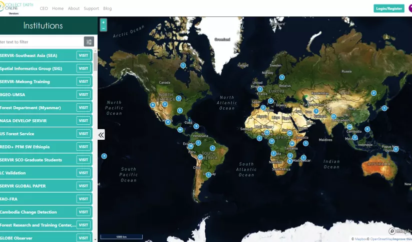
Collect Earth Online is a custom built, open-source, satellite image viewing and interpretation system developed by SERVIR, FAO, and other partners as a tool for use in projects that require land cover and/or land use data.
-
Supporting Climate Adaptation and Mitigation through Land Use/Land Cover Mapping in Myanmar
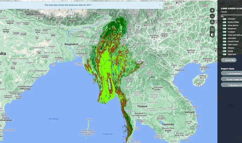
The Supporting Climate Adaptation and Mitigation in Myanmar service was a collaboration between SERVIR and Myanmar develop a National Land Cover Monitoring System, a web-based tool created using the cloud-based Google Earth Engine.

