
Bringing the Power of Google to Scientists in the Lower Mekong

Landscapes on Earth are changing at unprecedented levels. For scientists, practitioners and environmental decision makers, tracking these changes efficiently and accurately is critical to protecting lives and livelihoods. While there are many ways to learn about the dynamic nature of the Earth, satellite technology provides a unique perspective in observing our land, rivers, atmosphere and many other elements of the environment. For decades, access to this technology for effective decision-making has been a strenuous endeavor for scientists and development practitioners across the world, requiring high processing computers, access to troves of images, and technical expertise in advanced algorithm development, all of which require significant financial and technical resources.
Now, through a unique partnership with Google, the USAID and NASA partnered SERVIR-Mekong program is changing this reality for scientists and development practitioners across the Lower Mekong Region by leveraging Google’s high computing platform called Google Earth Engine (GEE).
What makes Earth Engine revolutionary
“The fundamental idea here is to move the question to the data instead of the other way around,” says Nicholas Clinton, GEE Developer. “Earth Engine provides access to petabytes of satellite imagery and a powerful cloud-based tool. This means that you can do advanced, big-data analysis of satellite imagery with a slow computer. That's what's revolutionary.”
With GEE, people can get their questions answered virtually instantly. Work that usually takes months is now processed in seconds. Financial resources that would have been spent on large servers and high-computing processors are extraneous and can instead be reallocated for other strategic purposes. For a region like the Lower Mekong, where scientists and development practitioners are thirsty for access to public satellite imagery, high processing computing, and cloud based algorithm development for rapid decision-making in near real time settings, GEE is changing the GIS world.
Meeting the demand
As a demand-driven program, SERVIR-Mekong crafts its activities around the needs expressed by decision-makers in the region. Chansopheaktra Sovann, Lecturer at the Royal University of Phnom Penh and part of SERVIR-Mekong’s University Partner Network, was the driving force behind a series of GEE trainings that the program has delivered across the region. “I was first introduced to GEE during an event I attended in 2015 and realized that this would be a very suitable mapping tool for developing countries like Cambodia,” says Sovann. “There is no need for high performance hardware, or big storage; and it is very fast which is perfect for people like me.”
Through a technical request mechanism provided on the SERVIR-Mekong website, Sovann submitted his interest in getting training on applied Python and JavaScript for GEE. Aligning perfectly with SERVIR-Mekong’s objectives for the region, the team began designing curriculum for a training.
Starting a wave of trainings
In partnership with the University of San Francisco, SERVIR-Mekong developed and tested a GEE curriculum that served as the backbone for a regional training event in Bangkok in July 2016. This was delivered in close partnership with the U.S. Forest Service and SilvaCarbon, bringing in 38 scientists from the region.
In this two-day training session, participants were introduced to and practiced working in the Earth Engine Code Editor platform (Google’s web-based JavaScript Application Program Interface); learned how to access, process and analyze data from the public data catalogue; and learned how to write their own programming for mapping purposes.
The regionalization of GEE
Given the high demand for this training, SERVIR-Mekong organized another workshop immediately following, but this time in Phnom Penh with new strategic partners including the Wildlife Conservation Society (WCS) who expressed interest to join SERVIR-Mekong as a co-host because of WCS’s important role in revising the Government of Cambodia’s Environmental Code. “Remote sensing on the GEE platform will be critical for setting environmental baselines and monitoring the efficacy of the new Code,” says Dr. David Ganz, SERVIR-Mekong’s Chief of Party. Similarly, The Asia Foundation saw this opportunity as fortuitous to their long terms goals to support regulatory reforms in Cambodia and provided financial contributions.

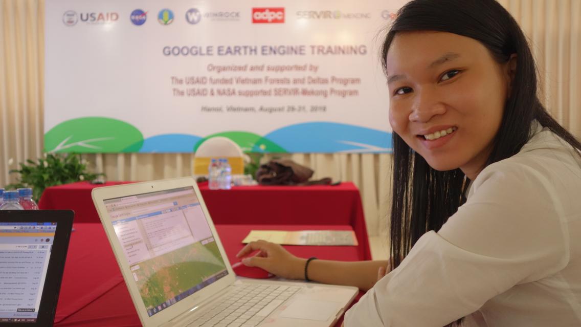
“Now that I have been introduced to Google Earth Engine I can see that it is much easier and faster to use
than the platform I currently have. My thesis is related to forest mapping for the Mekong region, and
when I return to my university I plan to change my analysis tool to Earth Engine.” - Nguyen Thien Hoa,
PhD student and researcher at Can Tho University, Vietnam. Photo: Sheena Agarwal
In August, a third training in Hanoi brought a new model to the wave of GEE trainings. In partnership with the USAID Vietnam Forest and Deltas activity, training materials were translated and sessions were delivered in Vietnamese. Additionally, SERVIR-Mekong engaged two Vietnamese participants from the Bangkok training to serve as co-trainers, promoting a training-of-trainers approach for sustainability and capacity building in the region.
“The best way for me to learn is to teach,” says Dr. Do Minh Phuong, Hanoi co-trainer and Senior Researcher at the National Institute for Agriculture Planning and Projection, Vietnam.
The way forward
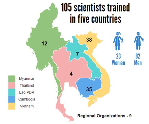
With three introductory courses completed, 105 scientists trained across the region, and a training in Yangon on the way, resolute demand in the region is clear. There has also been expressed interest in having another wave of GEE trainings, this time for advanced users, to strengthen the skill sets of environmental decision-makers in the region.
 |
Furthermore, Google is keen to continue this partnership with SERVIR-Mekong and expand the reach of its services to all corners of the world. “SERVIR’s tag line is ‘space to village’,” says Clinton. “That's exactly what Earth Engine does. It brings remote sensing capability to anyone with an internet connection and helps people with limited capacities answer environmental questions. Our interests are very well aligned and we look forward to this continued partnership.”
Notes:
The SERVIR-Mekong program is funded by the United States Agency for International Development (USAID) in partnership with the United States National Aeronautics and Space Agency (NASA); it is implemented by the Asian Disaster Preparedness Center in consortium with Spatial Informatics Group, Stockholm Environment Institute and Deltares.
For more information visit servir.adpc.net
This feature was prepared by SERVIR-Mekong’s Knowledge Management Lead Sheena Agarwal.