
SERVIR-Mekong Regional Land Cover System Showcased in First State of Land Report
The Mekong Region Land Governance Project (MRLG), funded by the Swiss Agency for Development and Cooperation, featured land cover maps created by the SERVIR-Mekong team in their 2018 Mekong State of Land Report. The report presents a comprehensive overview of land resources, distribution and governance conditions in the Mekong region, including Cambodia, Laos, Myanmar, Thailand, and Vietnam.
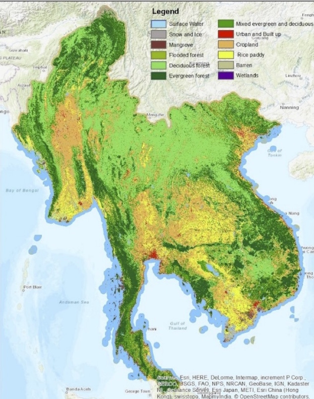 |
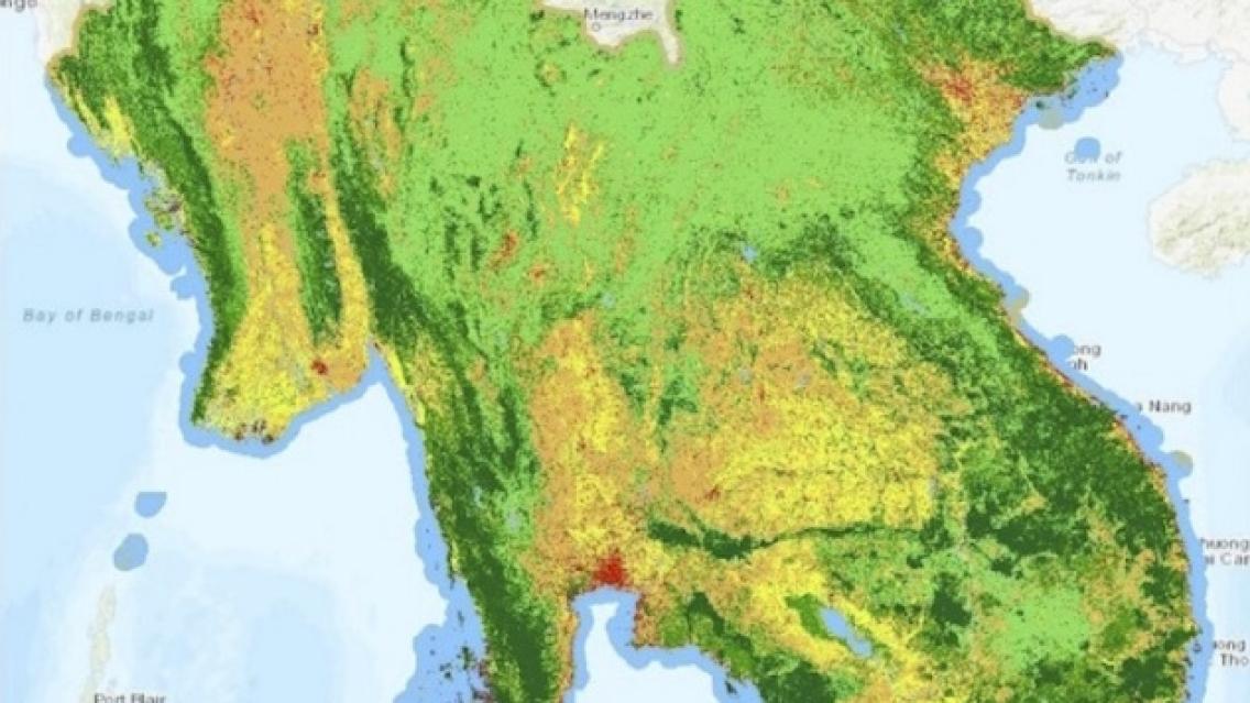
| The map shows land cover of the Lower Mekong region in 2015, produced by SERVIR-Mekong’s Regional Land Cover Monitoring Tool. |
Launched in May 2018 at the First Regional Land Forum in Bangkok, Thailand, the Mekong State of Land Report presents a comprehensive review of land resources, distribution and governance conditions in the Mekong region. The Centre for Development and Environment of the University of Bern (CDE) produced the report with support from SERVIR-Mekong.
The report relied on SERVIR-Mekong’s Regional Land Cover Monitoring System to inform regional assessment and cross-country comparative analysis of land use and land cover change in the Mekong region. This system helps overcome the changes posed by inconsistent national sources that use different classifications and definitions making it difficult to have consistent comparisons among countries with limited availability.
“SERVIR-Mekong’s data overcomes these obstacles with a consistent approach and classification system while the assessment is available on an annual basis allowing for accurate time-series estimates,” said Dr. Micah L. Ingalls, senior scientist at the Centre for Development and Environment at the University of Bern.
In addition to consultations and data provided for the State of Land Report, SERVIR-Mekong will continue to collaborate with the CDE on several fronts. The released draft report is the foundation for the sustained collection and analysis of indicators relevant for monitoring change in the Mekong region with regard to land-related issues. SERVIR-Mekong’s land use and land cover data will be crucial to this, particularly as there are no viable alternatives at this time. SERVIR-Mekong’s annual land cover data will also enhance the national impact assessment of land concessions in Lao PDR and Cambodia, currently being conducted by the CDE.
Furthermore, cross-analysis of data generated by SERVIR-Mekong’s dam inundation mapping tool and the Regional Land Cover Monitoring System will allow the CDE to accurately assess land and forest impacts and link these data to regional sustainable hydropower advocacy across the region.
The 2018 State of Land serves as a benchmark of current conditions, and sets a baseline for future measuring and reporting of progress in land governance in the Mekong region. The final version of the report is due to be released by the end of 2018. A draft version can be accessed here.
This article was originally featured on SERVIR-Mekong’s website. Click here to go to the original post.