
Small Satellites, Big Results: SERVIR integrates new high-resolution global datasets to improve environmental monitoring
Collecting Earth observations over tropical forests comes with logistical challenges. While protection of these often highly-vulnerable ecosystems is critical to combating climate change, heavy cloud cover and the cost of granular-level data mean that frequent, quality forest cover imagery can be a rare and valuable resource.
Increased access to high-resolution global imagery may be able to change that. Mosaics collected from “smallsat” data by the Norwegian International Climate and Forest Initiative (NICFI) are now being released to the public for free. Spanning the Earth’s tropical forests at a scale of fewer than five meters, these datasets include bi-annual imagery from December 2015 to August 2020, with new imagery added on a monthly basis. Sourced from Planet Labs with support from KSAT, these resources (and the decision to make them freely accessible) allow information from traditionally cost-prohibitive sources to be accessed by a much broader range of users.
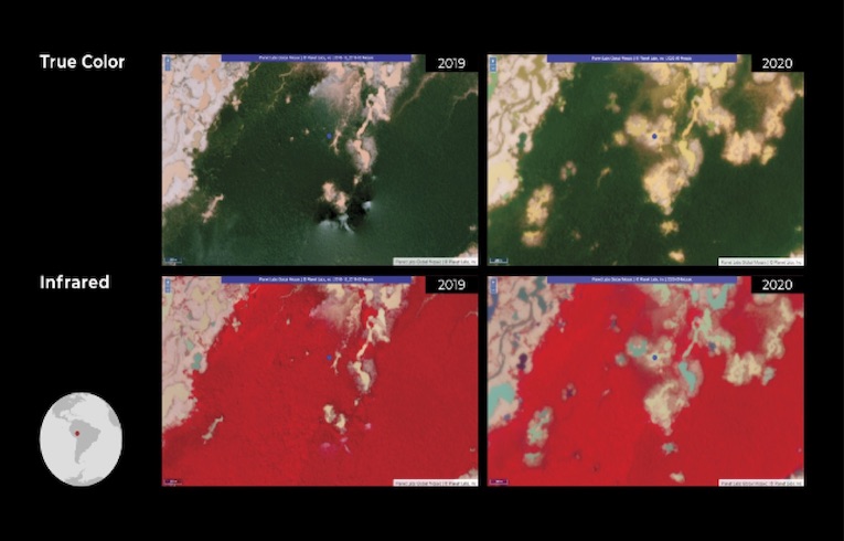
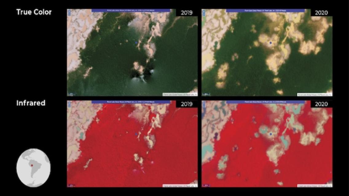
NICFI Planet imagery over the Peruvian Amazon in early 2019 (left column) and September 2020 (right column).
The top row represents true color imagery, while the infrared mosaics on the bottom provide a
more stark visualization of deforested areas. (Image credit: ACCA/Planet/L. Kucera)
NICFI’s Planet data are already being integrated into SERVIR’s global toolbox, with uses spanning across application areas and regions. The Global Forest Observations Initiative (GFOI) recently highlighted SERVIR’s use of high-resolution data for land cover and ecosystem applications in a December 2020 webinar, attended by over 500 participants.
By integrating these datasets, SERVIR’s ecosystem monitoring projects in Ghana and Peru are now better equipped to detect patches of deforestation. These patches, consisting of difficult-to-detect holes in the forest canopy, are frequently associated with small-scale artisanal gold mining and selective logging. Analyzing differences in forest cover over time can pinpoint illegal operations and help land managers target regrowth efforts. Similar methods could also be incorporated into agricultural services mapping plantation and other commodity cover types, as well as helping to reduce the uncertainty of carbon emission and sink estimates across the Amazon region.
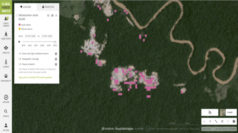
NICFI Planet imagery over the Peruvian Amazon with pixels flagged as “deforestation alerts” by the
Monitoring of Andean Amazon Project (MAAP), supported by the Global Forest Watch (GFW). Frequent, higher-resolution
imagery allows scientists to more precisely quantify when and where deforestation is occurring. (Image credit: ACCA/Planet)
Additional SERVIR land cover monitoring efforts benefiting from higher-resolution data include projects using the Collect Earth Online (CEO) platform. Implemented by a diverse group consisting of SERVIR, SIG, FAO, Google, and other partners, CEO helps assess land cover types and changes and has been widely used for global forest monitoring and carbon reporting applications.
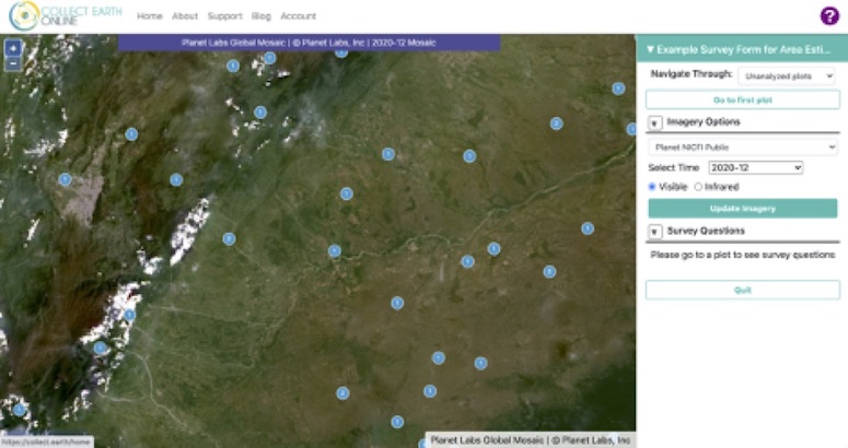
The Collect Earth Online (CEO) interface displaying a true color NICFI planet mosaic from December 2020. CEO allows users
to locate, interpret, and label reference data for use in classifying and monitoring land cover and land use change.
Blue dots represent user-generated plot survey points (Image credit: CEO/K. Tenneson)
Other regional services are likely to benefit from the closer look enabled by higher spatial resolution satellites. Monthly access to this level of imagery enables the use of more detailed information in space and time, as well as reliable background data to calibrate and validate automated services.
Potential applications are already being explored across the SERVIR network. In the Hindu Kush Himalayan region, NICFI data is beginning to be implemented into the Regional Land Cover Monitoring System (RLCMS) service, in addition to exploratory work integrating the datasets into flood inundation mapping and forecasting efforts. Further south, in the Mekong region of Southeast Asia, these mosaics could be woven into crop mapping and deforestation alerts in Cambodia. Thousands of miles away, services at the SERVIR-West Africa hub— including tools to locate seasonal watering holes and forecast optimal conditions for locust swarms—are also likely to benefit from NIFCI’s refined spatial scale.
Greater integration of datasets like the NICFI mosaics is not without its challenges; chief among them being the vast increase in the volume of data that has to be processed by each service. This in turn has the potential to slow down processing times, as well as create a need for additional computing power to complete tasks.
“Accessing Earth observation data at a finer level of detail and at a higher frequency is already opening up new opportunities for land cover, land use, and ecosystem monitoring services,” said Emil Cherrington, Regional Science Coordination Lead for SERVIR-West Africa and land cover specialist.
As the SERVIR network expands the use of machine learning techniques and approaches, processing can be done more efficiently across a wide variety of research areas—reducing the hurdle that big data once was.
NASA’s existing agreement with Planet Labs is already improving the SERVIR Applied Science Team’s ability to accurately map commodity crops and forest degradation in remote areas in the Amazon. Future integration of high-resolution datasets from Planet and the NICFI agreement will continue to enhance the utility of Earth observation tools and services.
“Despite the ‘big data’ challenge, NICFI and Planet data pose an exciting prospect for us in the SERVIR network, as well as in the broader Earth observation community,” added Cherrington.
Written by Jake Ramthun and Leah Kucera of the NASA SERVIR Science Coordination Office. Additional reporting by Africa Flores-Anderson and Emil Cherrington.