
Virtual Hackathon aids SERVIR-Mekong in water management applications, preparation for upcoming SWOT mission
The SERVIR-Mekong hub in Bangkok, Thailand is working on applications for a future satellite mission to enhance water resource management in the Lower Mekong region.
In May 2020, NASA and the University of Washington hosted a virtual “hackathon” for early adopters of the Surface Water and Ocean Topography (SWOT) mission (scheduled for launch in 2022). The mission is a joint effort between NASA and the French, Canadian, and U.K. space agencies, intending to develop the first global survey of Earth’s surface water.
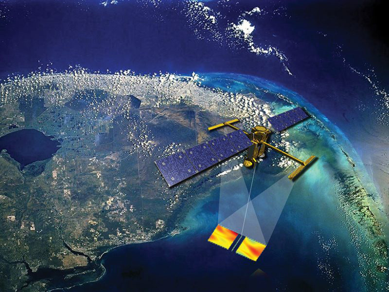
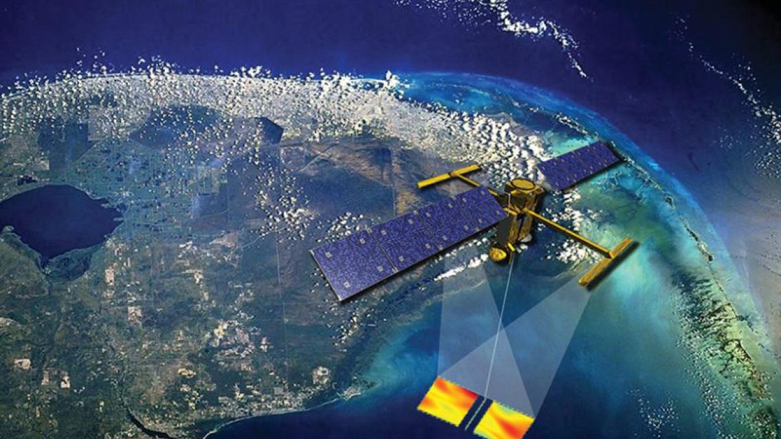
An artist's impression of the future SWOT satellite making sea surface height observations, even through clouds.
This satellite will offer researchers new opportunities to study the oceanic dynamic processes over the global oceans
in high resolution. https://swot.jpl.nasa.gov/resources/87/artists-impression-of-the-swot-satellite/ (Source: CNES)
The hackathon is a part of the NASA Applied Sciences Program’s “early adopter” initiative, engaging scientists and institutions in proposing activities for planned satellite data. This initiative helps identify potential applications long before the satellite’s launch and actual data collection. Typically, SWOT early adopters represent oceanography and hydrology institutions involved in pre-launch research that will enable their organizations to use SWOT data in future tools and decision-making.
One of the event organizers, University of Washington professor Dr. Faisal Hossain, is a project investigator for the SWOT mission and a current NASA Applied Sciences Team member with SERVIR-Mekong. When Dr. Hossain began his work with the SWOT mission, he encouraged scientists from the hub to join as early adopters (EAs).
As EAs, SERVIR-Mekong and hosting institution the Asian Disaster Preparedness Center (ADPC) are focusing on the use of SWOT to enhance water resource management. Currently, ocean tidal effects create difficulties in monitoring water levels in the streams of the Mekong River delta. Using SWOT data, SERVIR-Mekong and ADPC will be able to develop a new system of virtual stream gauges, which can improve methods like the existing Variable Infiltration Capacity (VIC) model, used to forecast water levels in the region.
“We [at the hub] are developing many innovative geospatial tools and platforms...My main responsibility is to develop the applications that can be used with SWOT-like products for filling the existing gaps of current remote sensing datasets. Once the SWOT mission is operationalized, these applications would help people and countries tackle environmental and social issues,” said attendee Susantha Jayasinghe, technical specialist for SERVIR-Mekong.
One specific application could be for SERVIR-Mekong’s online water monitoring tools, as well as in flood forecasting. Fellow attendee Pin Meechaiya, a hydrologist and senior project coordinator at SERVIR-Mekong, noted “I will test and use SWOT products such as water level, discharge, surface water, etc., in the SERVIR-Mekong water dashboard and introduce it to stakeholders in the region to enhance their decision-making in flood management.”
The current COVID-19 pandemic presents challenges to what would typically be in-person events. The hackathon was held virtually on the web-conferencing platform Zoom with four goals in mind: “medically safe (contactless), scalable (cost-effective), rapidly-deployable, and focused on learning outcomes (MEDSCARF),” with outcomes and event organization detailed in an early publication in the Bulletin of the American Meteorological Society.
For the hackathon event, programmers and researchers were brought together to collaborate and build skills using a tool simulating the types of data that will be generated by the SWOT mission. The event included pre-orientation materials as well as volunteer helpers made up of University of Washington graduate students and other data experts for each early adopter in attendance.
Participants were first able to observe a live, hands-on demonstration on generating inputs for the SWOT simulator using Google Earth Engine, followed by introductions to the SWOT CNES Hydrology Simulator, the SWOT Ocean Simulator, and the Global Reservoir Assessment Tool.
Additional sessions consisted of 2-hour intensive breakout sessions, as well as a group discussion. These breakouts aimed at “looking under the hood” of each of the models, datasets, and tools. In each session, attendees and helpers shared code scripts, files, and sample data using Zoom’s file transfer protocols. Separate “rooms” in the Zoom application enabled discussions and troubleshooting of any issues encountered as the sessions progressed. After the event, each participant was able to discuss future needs and planning for their respective applications.
The event organization and individual guidance helped increase the hackathon’s effectiveness in the new virtual environment. According to the BAMS article, providing learning materials before the 2020 Hackathon produced a “200% increase in EA interaction and resolution of project issues” from the 2019 Hackathon. The early adopter teams also “demonstrated better coordination and preparation for the hackathon one-on-one live session.”
SERVIR-Mekong’s attendees agree on the event’s convenience, timeliness, and clarity. “I was able to get a better understanding of what the simulator is and how to properly use it for SWOT-like water elevation data generation for our pilot river (Chindwin) in Myanmar,” said Jayasinghe. Meechaiya, who especially appreciated the one-on-one breakout sessions, noted “I would say it surprised me that a virtual meeting could be so productive!”
The SWOT Hackathon’s virtual success could set a precedent for future events of its kind. Hossain and his co-authors propose “that the concept and lessons learned be adopted across all planned NASA and CNES satellite missions in anticipation of the post-COVID-19 era of a more globally-connected community.”
Written by Nicole Moore of the NASA SERVIR Science Coordination Office.
SERVIR connects space to village by helping developing countries use satellite data to address critical challenges in food security, water resources, weather and climate, land use, and natural disasters. A partnership of NASA, USAID, and leading technical organizations, SERVIR develops innovative solutions to improve livelihoods and foster self-reliance in Asia, Africa, and the Americas. SERVIR’s Mekong hub, created in 2014, began research to develop new tools to monitor climate risks for the Lower Mekong region. SERVIR-Mekong is primarily implemented by the Asian Disaster Preparedness Center (ADPC).