
Strengthening Climate Resilience from Space
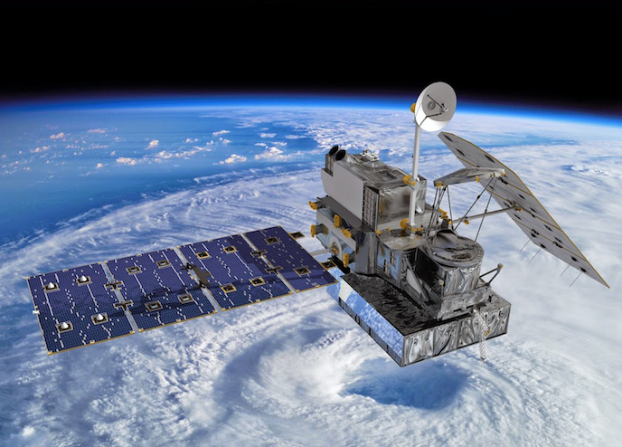
Artist's concept of the Global Precipitation Measurement Core Observatory, a joint international project of
NASA and the Japan Aerospace Exploration Agency, that measures rain and snow. Image credit: NASA
How a 15-year partnership between USAID and NASA is helping partners avert disaster
At first glance, USAID and NASA seem like an unlikely pair. NASA’s satellites watch the world from above; USAID helps farmers around the world grow crops from the ground up. But through a 15-year partnership, we’re helping solve one of Earth’s greatest threats — the climate crisis — and simultaneously strengthening resilience against poverty, hunger, malnutrition, and lack of access to safe water and sanitation. Together, we’re connecting space to village.
SERVIR, the joint program between USAID and NASA, uses satellite images from space to track climate shocks, like droughts, floods, and dramatic changes in water levels — all challenges that can devastate families and entire nations.
Through observations and data from space, USAID and NASA are tracking weather patterns in 50 countries, and working with local experts on the ground to ensure that these findings can best be leveraged to fit specific local needs so that families can take action ahead of a crisis.
Keshab Prasad Kadel, a teacher in Nepal, leveraged SERVIR technology to track potential flooding
in small river stretches that border his hometown during last year’s monsoon season.
Gone in a flash
Take flooding as an example. In countries like Nepal and Bangladesh, flooding is a chronic challenge that has grown worse over time due to climate change — particularly flash floods, which are especially difficult to predict.
SERVIR-Hindu Kush Himalaya, implemented by the International Centre for Integrated Mountain Development (ICIMOD) in Kathmandu, Nepal, has collaborated with NASA to develop a 48-hour flash flood forecast for rivers in Nepal and Bangladesh. As this information gets into the hands of local partners, decision-makers on the ground can stay ahead of a potentially devastating flood and save lives and livelihoods. SERVIR is also making this vital information open to the public and into the hands of local change-makers through a mobile app and daily flood bulletins.
During the monsoon season, outputs from SERVIR’s digital platforms are continuously used to disseminate information to ICIMOD’s partners, including Bangladesh’s Flood Forecast and Warning Center (FFWC) and Nepal’s Department of Hydrology and Meteorology (DHM), plus local NGOs and civil society actors. ICIMOD’s partners use SERVIR’s flood early warning services as part of a decision support system for flood forecasting. These services assist decision makers and managers in providing flood early warnings and response decisions during extreme events. The FFWC has also collaborated with ICIMOD on a mobile application to make flood warning information more accessible to the public. The DHM regularly references the outputs of SERVIR’s prediction tools in their daily flood bulletins. Furthermore, these tools are included in the Government of Nepal’s BIPAD (Building Information Platform Against Disaster) platform for disaster risk reduction and response.
Going beyond the partnerships with host country hydrology and meteorology departments, SERVIR’s work is helping communities be more resilient in the face of floods. For example, every year, secondary school teacher Keshab Prasad Kadel used to watch floods and landslides inundate farming land and damage major infrastructure in his hometown of Dhading, a city northwest of Kathmandu. After seeing SERVIR technology accurately predict flooding from the Malekhu River near his hometown, he immediately saw the value in this information and went to ICIMOD to learn how to use these tools. Subsequently, during the 2020 monsoon season, when Mr. Kadel saw a flood forecast for the small river stretches that border his hometown, he relayed this vital information to officials and members of his community. In response, the community took decisive, preventive action which minimized flood damage, saving property and possibly even lives.
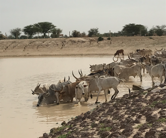
Cattle in Leinguere, Senegal cool down in a small, maintained pond while pastoralists tend to other business from
the sparse shade trees. Photo credit: Rebekke Muench, NASA SERVIR Science Coordination Office
Chasing water
In West Africa, long dry seasons characterize the savannah landscape of northern Senegal’s Ferlo region, an area with a rich tradition of pastoralism. Herders depend on cattle, sheep, and goats for both their financial and food security, but increasingly fickle environmental conditions are making it difficult to raise these essential livestock. For example, while water and food for livestock are abundant during the rainy season, pastoralists rely on seasonal ponds during the dry season to keep their animals alive.
Unfortunately, climate change is causing increasingly shorter rainy seasons and drying up water sources. For example, in Niger a decade ago, a drought killed a quarter of the herd, which translated to a loss of more than $700 million for the country’s economy. To ease this uncertainty, SERVIR-West Africa’s consortium members at the Centre de Suivi Ecologique (CSE) are using data from a constellation of satellites to determine in near-real time where water can be found. CSE has partnered with Agronomes et Vétérinaires Sans Frontières (AVSF) and community radio stations to broadcast this critical information so that pastoralists can chart the best course of seasonal migration in their search for water and pasture, keeping their livestock and way of life secure.
Forecasting for the future
In Guatemala, Honduras, and El Salvador, SERVIR is reducing the impact of extreme weather events, which contribute to the multifaceted drivers of irregular migration. Most recently, this technology was used in the devastating aftermath of back-to-back Hurricanes Iota and Eta — which affected millions of people and caused severe flooding, landslides, and damage.
Through SERVIR, NASA partnered with the Coordination Center for the Prevention of Natural Disasters in Central America (CEPREDENAC) to manage these shocks through flood mapping and forecasting. With NASA support, this regional disaster management agency was able to leverage technology to help a major hydroelectric dam in Honduras safely manage stormwater collected in the reservoir. This prevented even greater flood damage in the region, and the downstream economic hubs.
Scaling for impact
SERVIR’s technologies are replicable, bringing solutions to other regions facing similar challenges. While local context and partners are critical components for informing the needs and design of a SERVIR service, the algorithms and automated techniques often can be repurposed to another region. For example, SERVIR-West Africa’s ephemeral water body service is being considered for application in other parts of West Africa’s dry Sahel region. To the point of adapting, scaling, and replicating, that technology was originally adapted from SERVIR’s work in the Mekong region in southeast Asia, where USAID and NASA developed a surface water mapping tool to assess the risk of floods and impacts from existing and proposed dams.
From space, we can prepare for hazards and sound early warnings when we foresee potentially devastating crises. Applications using satellite data not only yield accurate real time and forecasted information but also create efficiencies and can be applied to areas with limited ground data and in remote or hard-to-access areas. And we’re scaling this technology across the world to get ahead of these mounting risks, strengthening the climate resilience of vulnerable regions every day.
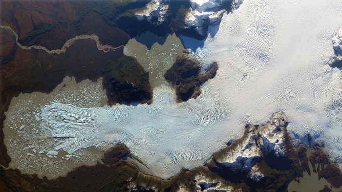
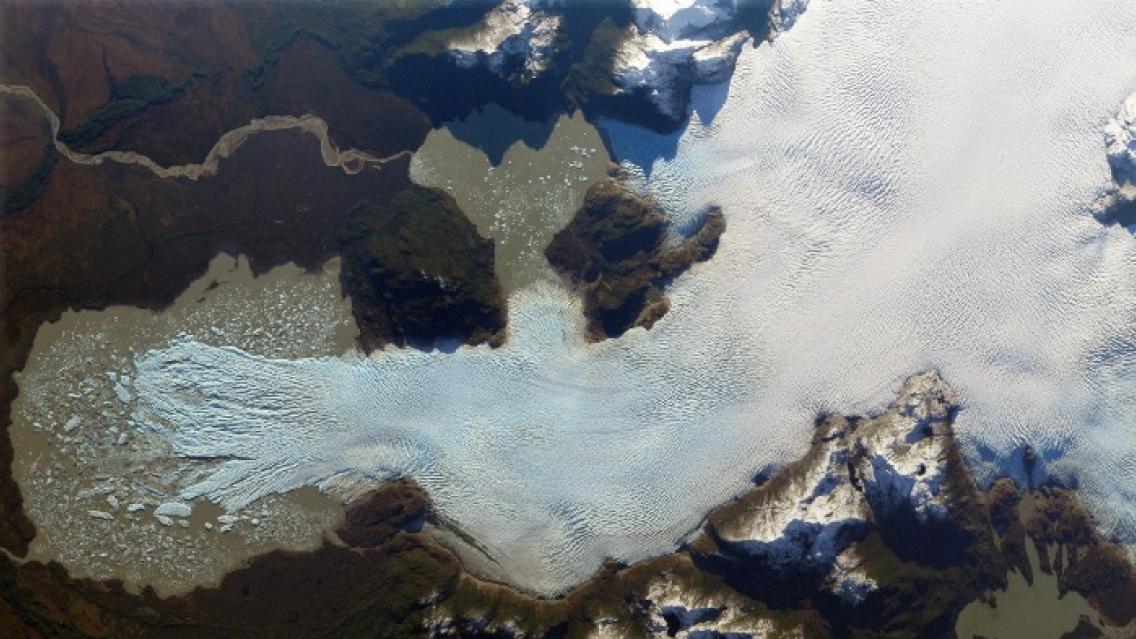
Images from an International Space Station camera show how Glaciar San Quintin, the largest glacier in Chile’s
Laguna San Rafael National Park, a UNESCO-designated World Biosphere Reserve, is rapidly shrinking,
as are other glaciers in the region. Photo credit: NASA / SERVIR
Future-proofing Earth from space
As the climate crisis intensifies with more frequent and stronger storms, droughts, heatwaves and other climate events, strategies to reduce vulnerability become more critical for more people. In many cases, responding in the aftermath of a devastating flood or drought means too many lives and livelihoods lost. From the unique vantage point of space, we can rapidly decipher the kind of life-saving details that would be nearly impossible to gather from Earth. At a time when tackling extreme weather events requires renewed action and commitment — such as what we’re seeing this week at the Leaders Summit on Climate — innovation and collaboration are vital to future-proofing our precious natural resources.
For 15 years, USAID and NASA have empowered more than 10,000 people in 50 countries, working closely with partners on the ground so that satellite data can be effectively leveraged at the village level. SERVIR’s approach is to empower organizations and governments to develop and sustain decision support solutions for their own use. The examples presented here are just some of the more than 30 custom services SERVIR has co-created with its international partners. These examples demonstrate the value of Earth observations and geospatial data, tools, and services to advance international development and adaptation to climate change through science and technology. SERVIR’s name is derived from the Spanish word meaning "to serve"—and as the climate crisis accelerates, this partnership will continue to serve the most vulnerable people to help them survive and thrive.
A version of this blog post originally appeared on USAID’s Medium page on Earth Day 2021: https://medium.com/usaid-2030/strengthening-climate-resilience-from-space-7a19d0852426