
Collect Earth Online helps fight illegal mining in Amazon
Collect Earth Online (CEO) is helping to stop illegal mining in the Peruvian Amazon, protecting primary forests and the indigenous communities who live in the region.
Illegal mining continues to devastate forests in southern Peru, destroying more than 100,000 hectares of old-growth forest within protected areas and indigenous territories over the past three decades. Mining causes deforestation and forest degradation, and it also contaminates water and soil, undermining the ecosystems that local people depend on for survival.
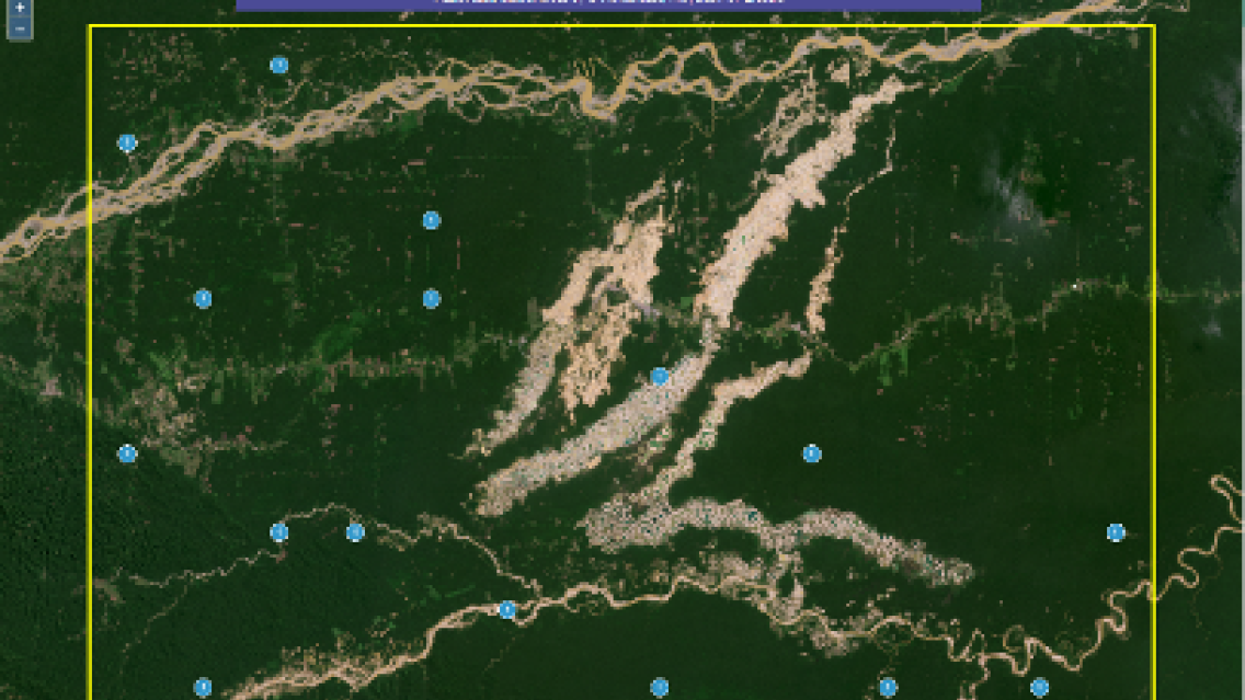
A platform known as RAMI, short for Radar Mining Monitoring, fights these activities through satellite data. In the RAMI platform, synthetic aperture radar (SAR) data is used to generate near-real-time alerts about where mining may be taking place. Those alerts are then validated—i.e., examined to verify that mining is actually taking place—using satellite imagery in CEO, including high-resolution data available from Planet through Norway’s International Climate & Forests Initiative (NICFI).
RAMI was developed by SERVIR Amazonia—a joint initiative of USAID and NASA—along with the Peruvian NGO Conservación Amazónica (ACCA) and Spatial Informatics Group (SIG).
Legal authorities “want to be sure the mining activity is happening before they send the police and environmental prosecutors to the area,” says Milagros Becerra, Project Monitoring Coordinator - SERVIR Amazonia with ACCA. “With RAMI, they can focus on the specific places where illegal mining is happening.”
A tool to monitor forests
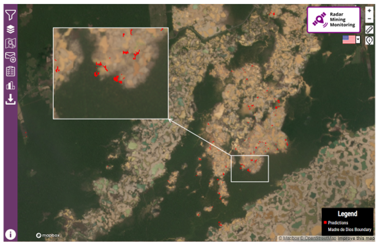
The RAMI user interface indicates where mining activity may be taking place. High-resolution imagery from Planet, made possible by NICFI, is available to help support validation efforts.
Illegal mining doesn’t just destroy forests. It also hurts fishermen, tourists, and people who live downstream, whose food and water are often contaminated by products of mining.
“They use mercury to extract the gold, which ends up in the rivers, and these rivers flow through many small villages and even the principal cities,” says Lucio Villa, Technical Specialist in GIS and Remote Sensing with ACCA. “The people who work in the mines also get sick from mercury.”
The Peruvian government’s anti-mining efforts focus on the Madre de Dios region, which has been particularly hard hit. RAMI has two major objectives: first, to quickly identify new illegal mines in priority areas, especially indigenous territories and the buffer zones around protected areas; and second, to monitor persistent mining activity in areas that are already degraded, in order to understand how these mines impact forests and communities.
Because illegal mining tends to happen in remote areas, the best view is from space. The SAR observations used by RAMI come from the European Space Agency's Copernicus Sentinel-1 satellite.
Crucially, SAR works even when there is heavy cloud cover—which means it functions even during the rainy season, which lasts five to seven months of the year.
“The novelty of using synthetic aperture radar or SAR in a near-real-time detection system in the Amazon is unique,” said Sidney Novoa, ACCA’s Director for GIS and Technology Applied for Conservation. “Because radar penetrates through clouds, it makes it possible to generate and obtain consistent and frequent information on gold mining areas year-round.”
RAMI uses Google Earth Engine to process large amounts of SAR data using an algorithm that detects even small changes in land cover and generates alerts.
RAMI is “a near-real-time alert system that improves the precision, efficiency, and accuracy of the detection of new illegal mining sites,” Villa says.
But these initial alerts aren't always accurate, which is why CEO plays a key role in the RAMI workflow.
CEO validates early alerts
In some cases early alerts in RAMI are triggered by the formation of a sandbar in a river, the planting of crops, or the building of a road. It’s important to weed out these false positives from genuine mining activity, because officials need to have confidence in the alert before they plan a route to suspected mining locations and take action on the ground.
CEO delivers that confidence by providing a way to validate the early alerts with other layers and satellite images.
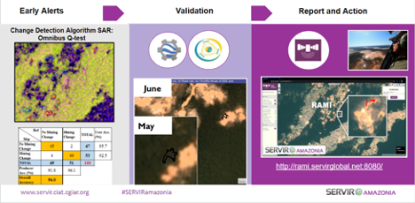
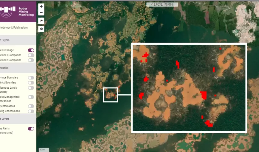
The RAMI workflow: the change detection algorithm uses SAR observations
and a change detection algorithm to generate alerts, which are then
validated using Collect Earth Online. Validated reports are forwarded
to the appropriate authorities. Image courtesy ACCA.
Data from the early alerts is uploaded to CEO, where a survey is created with the land classes and the date of the change. This allows the information derived from SAR to be confirmed through comparison with high-resolution optical imagery available in CEO.
Once confirmed, RAMI generates bulletins that are shared with stakeholders.
“We have a contact list of 70 users of RAMI who receive a monthly bulletin identifying new fronts of mining activity,” Becerra says. “RAMI helps us understand where the mining hotspots are located, so the end users can download this information and take actions in the field.”
RAMI is co-developed by the National Program of Forest Conservation and Climate Change of the Peruvian Ministry of Environment. Commonly known as Geobosques, this national program also calculates annual rates of deforestation and the location of deforestation. Other users include federal and regional officials and the geospatial information unit of protected areas (Servicio Nacional de Áreas Naturales Protegidas - SERNANP).
The Environmental Prosecutor’s Office in the Madre de Dios region uses information to plan field operations against illegal mining. Information on mining is also shared with representatives of indigenous organizations and others who rely on the forest.
In a case of illegal mining near the indigenous community of San José de Karene, information from RAMI was shared not only with the environmental prosecutor but also with the leaders of the indigenous community. With such information, the leaders “can identify the coordinates and communicate with environmental prosecutors to protect the forest,” Becerra said. “RAMI gives indigenous communities the ability to protect their individual territory and reduce the deforestation rate.”
Data from the validation process is also fed back into RAMI in order to improve the change detection algorithm and make the early alert system more accurate.
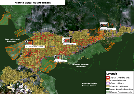
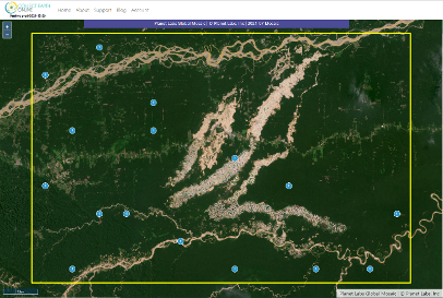
Points of early alerts due to mining close to important and priority areas for conservation.
1) San Jose de Karene Indigenous Land 2) Buffer zone of National Park Tambopata,
3) Shiringayoc Indigenous Land, 4) Bajo Pariamanu River.
Big role for Planet NICFI and Geo-Dash
Becerra highlighted the importance of high-resolution imagery from Planet NICFI. The Planet basemaps, with a resolution of less than 5 meters per pixel, are updated roughly every month, providing access to a consistent, date-stamped data source that allows detection of even minor changes in the landscape.
Planet NICFI imagery shows gold mining activities in
Puerto Maldonado, Peru. Image courtesy ACCA.
“Planet NICFI has many advantages, especially that it allows you to easily compare images, month by month, to detect the mining activities,” Becerra says. “And with the infrared imagery, we can compare and see another point of view.”
Becerra described a recent RAMI bulletin for an area near Tambopata National Reserve.
“We have the Planet NICFI imagery for November, and we are comparing it with another image from December,” she explained. “In the first it was forest, and then it was mining activity.” That sort of clear photographic evidence is crucial when law enforcement takes action.
Also important to RAMI is CEO’s Geo-Dash Degradation Tool, which helps users verify cases of forest degradation by combining the Normalized Difference Fraction Index (NDFI) with a time series of satellite imagery, allowing users to detect even subtle and short-lived changes in the forest canopy.
NDFI expresses what portion of a plot of land is covered by green vegetation as opposed to bare soil or non-photosynthetic (dead or dormant) vegetation. Having a time series helps avoid confusion between seasonal vegetation patterns and forest degradation.
With Geo-Dash, “we can improve our analysis and make a clean dataset of the gold mining activity,” Becerra says.
“Many of our users are not GIS experts—they are specialists in other fields,” Becerra says. But RAMI allows them to clearly understand what is happening on the ground.
Better technology to improve lives
RAMI has performed significantly better than other alert systems in detecting illegal gold mining activities. And the validation of alerts through CEO reduces the costs of field verification. In short, RAMI closes the divide between satellite data from space and law enforcement activity on the ground.
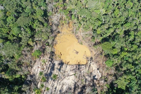
What illegal gold mining looks like. Photo credit: ACCA.
As a result, forests in the Amazon remain intact and rivers avoid toxic contamination. Just as important, indigenous communities can lead better lives.
“The information is very important because in one way or another it supports what one can make known,” says Julio Cusurichi, the president of the Native Federation of the Madre de Dios River and Tributaries. “if there is an invasion in a community’s territory, it can be relayed by phone, but it is much better when there is photographic or video evidence.”
Collect Earth Online is supported by ongoing funders FAO, NASA SERVIR, and SilvaCarbon. Norway’s International Climate & Forests Initiative (NICFI) funds open high-resolution data availability through Planet, and the Google Earth Engine team provides a platform for Earth science data and analysis.
SERVIR-Amazonia is implemented by the Alliance of Bioversity International and the International Center for Tropical Agriculture (CIAT), as well as a network of local and international partners including ACCA, Spatial Informatics Group (SIG), the Institute for Forest and Agriculture Management and Certification (IMAFLORA), and Fundación EcoCiencia.
-
Collect Earth Online (CEO)
Collect Earth Online is a custom built, open-source, satellite image viewing and interpretation system developed by SERVIR, FAO, and other partners as a tool for use in projects that require land cover and/or land use data.
-
Monitoring of Gold Mining in the Peruvian Amazon
The Monitoring of Gold Mining in the Peruvian Amazon service produces near real-time information on deforestation and mining activity in the southern Peruvian Amazon.

