
Preparing for the 2019 floods in Bangladesh

Bangladesh's vulnerability to floods persists even after the devastating 2017 floods, which took a heavy toll on the nation's people and infrastructure. Climate change-driven calamities put the lives of millions in the country at risk, as pointed out in a 2019 United Nations Children's Fund (UNICEF) report. To ensure effective preparation for any upcoming floods in 2019, the Bangladesh Water Development Board (BWDB), Flood Forecasting and Warning Centre (FFWC), with support from the International Centre for Integrated Mountain Development (ICIMOD), held a stakeholder consultation workshop in Dhaka on 5 March 2019.
The stakeholder consultation workshop focused on improving flood forecasting in Bangladesh.
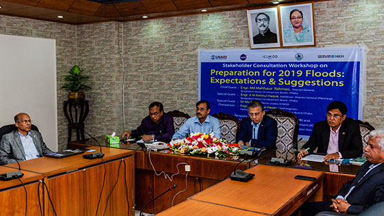
[L-R] Mir Matin – Theme Leader of Geospatial Solutions, ICIMOD, and Science and
Data Lead, SERVIR-HKH; A. K. Manzur Hasan, Chief Engineer, Hydrology, BWDB;
K. M. Anwar Hossain, Additional Director General (ER), BWDB;
Md. Mahfuzur Rahman, Director General, BWDB; and A. M. Aminul Haque,
Additional Director General (Planning), BWDB (Photo: Utsav Maden)
Md. Mahfuzur Rahman, BWDB's Director General, attended as the event's Chief Guest. K. M. Anowar Hossain, Additional Director General (East Region), BWDB, and A. M. Aminul Haque, Additional Director General (Planning), BWDB, served as special guests, while A.K. Manzur Hasan, Chief Engineer, Hydrology, BWDB, chaired the technical session during the half-day programme. Prior to the workshop in Dhaka, BWDB/FFWC also organized stakeholder engagement workshops in two of the most vulnerable flood hotspots in Bangladesh – Serajgonj and Bogra – on 25 and 26 February 2019, respectively.
The workshop brought together senior officers from different divisions within the BWDB, representatives from the Bangladesh Meteorological Department (BMD), Institute of Water Modelling (IWM), Department of Disaster Management (DDM), Department of Agriculture Extension (DAE), ICIMOD, and members of the Bangladeshi media to the BWDB's head office in Dhaka, Bangladesh. The workshop introduced the FFWC's improved flood forecasting abilities and the mobile app – BWDB Flood Apps – which was developed to make flood warning information more accessible to the public.
FFWC’s improved flood forecasting abilities
ICIMOD worked with the FFWC in Bangladesh to develop a custom application that generates stream flow forecasts at 17 boundary locations along the India–Bangladesh border. As 92% of the watershed areas lie outside of Bangladesh, the FFWC does not have access to stream flow information in upstream areas, thereby limiting its flood forecasting capability to 3–5 days of lead time. With the new inputs being fed to the FFWC’s flood forecasting model, FFWC engineers now have a better understanding of stream flow in upstream rivers, thereby significantly improving their capacity to deliver better and effective flood warnings.
Md. Mahfuzur Rahman commended the FFWC for organizing such a workshop ahead of the flood season for the first time and acknowledged assistance from the United States Agency for International Development (USAID) and the National Aeronautics and Space Administration (NASA) in improving the FFWC's flood forecasting capabilities. He also welcomed the improved lead times and accuracy in FFWC's flood forecasts through the collaboration with ICIMOD and provided recommendations on further progress.
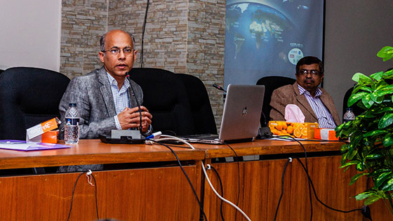 |
| Mir Matin – Theme Leader of Geospatial Solutions, ICIMOD, and Science and Data Lead, SERVIR-HKH – shares ICIMOD and the BWDB's rich history of collaboration on access to data and use of satellite data (Photo: Utsav Maden) |
Mir Matin – Theme leader of Geospatial Solutions, ICIMOD, and Science and Data Lead, SERVIR-HKH – thanked the BWDB for the opportunity to collaborate on this initiative. He added that the two institutions share a rich history of collaboration in data sharing and satellite information use to improve flood forecasts through the Establishment of a Regional Flood Information System in the Hindu Kush Himalayan Region (HKH-HYCOS) project and SERVIR Hindu Kush Himalaya (SERVIR-HKH) programme. He added that through SERVIR – a joint initiative of USAID and NASA – ICIMOD was able to bring in the rich expertise of representatives from top universities and institutions in the United States of America.
Md. Arifuzzaman Bhuyan, Executive Engineer, FFWC/BWDB, provided an overview of the FFWC's operational modalities around floods and how the collaboration with ICIMOD brought forward new information on stream flow forecasts by downscaling coarser-level global modeled outputs. He also showcased the BWDB Flood App – a mobile application for the android platform developed to disseminate flood warning information. With mobile phone penetration rates among the highest in South Asia, the mobile application aims to facilitate information dissemination to a wider audience during flooding season.
The workshop was followed by a two-day training for FFWC staff on forecast validation using the Hydrostats application, an open-source web-GIS suite developed by the SERVIR Applied Sciences Team from Brigham Young University.
Upon the FFWC's request, ICIMOD also supported development of a mobile application.
The application enables dissemination of the flood warning information to a much wider
audience, including field-level managers and vulnerable communities, during flooding season.
Written by Utsav Maden of SERVIR-HKH/ICIMOD. This article was originally featured on SERVIR-HKH's website. Click here to go to the original post.