
Tracking Earth's Forests
A new paper published recently in Environmental Research Letters – Reviews and led by SERVIR Applied Sciences Team member Scott Goetz, details the “state-of-the art” of techniques and tools available for keeping track of the Earth’s forests and their changes. It also describes new technologies that will take such tracking to a new level.
It is critically important to measure and monitor our planet’s forested areas, not only because they provide habitat for wildlife and sustain forest communities, but also because they take in large amounts of carbon and release oxygen. When forests are removed or degraded, there are many repercussions. Animal populations are diminished, less carbon is removed from the atmosphere via forest growth, and carbon emissions to the atmosphere are increased from decay of plant material and warming of soils that were previously shaded by tree cover. These effects of deforestation are known to hasten global warming and increase its impact.
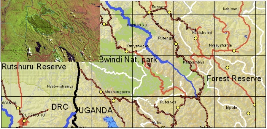
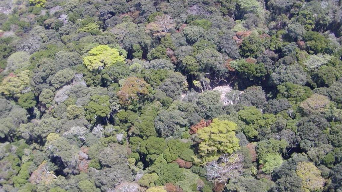
Forests of the tropics are undergoing dramatic changes as a result of human land use for agriculture to feed burgeoning populations. REDD+ will try to balance these needs while preserving valuable forests like those of the Bwindi National Park (shown here) located in East Africa at the boundary of Uganda, Rwanda and the Democratic Republic of the Congo. Many of the forests remaining in East Africa are completely surrounded by agriculture and disconnected from other forests of the region, isolating species like Bwindi's famous endangered mountain gorillas, in forested island habitats. |
A United Nations Framework Convention on Climate Change (UNFCCC) program called REDD+ supports forest conservation by funding tropical countries in proportion to their efforts to protect forests and reduce greenhouse gas emissions, particularly CO2. Countries engaged with REDD+ (short for Reducing carbon Emissions resulting from Deforestation and forest Degradation) need accurate information about the extent and density of their forests in order to assess their carbon stores and potential for emissions to the atmosphere. Countries also require this information to maintain natural forests while balancing needs for sustainable development. With state-of-the art satellite remote sensing tools and strengthened technical capacities, countries can conduct accurate forest inventories as well as map and monitor land use change activities.
Goetz, co-I Nadine Laporte, and other co-authors released their new paper* detailing REDD+-related needs and capabilities at the November UNFCCC 21st Conference of the Parties (COP21) negotiations in Paris, where they made the case that measurement and monitoring capabilities are in place for REDD+ implementation.
“Coming into COP21, REDD+ was hanging in the balance and needed a push over the top,” says Goetz. “We made a point to finish our synthesis paper in time to inform the negotiations in Paris. By providing an overview of the capabilities and potential for REDD+ monitoring, our synthesis makes it clear that the technology is up to the task and will only get better.”
The review paper focuses on what is possible now in terms of measuring and monitoring forest carbon, what kinds of improvements are needed, and new technologies that will soon provide those improvements. It discusses how remote sensing is used to (1) set baselines by measuring changes in the current and past extent of forests, (2) measure the carbon stock density of forests to estimate emissions in deforested or degraded areas, and (3) understand the dynamics of forest regrowth following disturbance. The paper also describes emerging new technologies that will greatly enhance REDD+ implementation.
A prime example of these new technologies is a laser (lidar) instrument to be installed on the International Space Station. Called the Global Ecosystem Dynamics Investigation (GEDI) lidar, it will soon make it possible to map carbon stocks and monitor changes across forests at much higher resolution and with greater accuracy. The instrument will shoot laser beams into tree canopies of the world’s forests to take fine-scale measurements of their height and internal structure, enabling accurate estimation of their carbon content.
“… the GEDI data will provide us with global-scale insights into how much carbon is being stored in forest biomass,” says Piers Sellers, deputy director of NASA Goddard Space Flight Center’s Sciences and Exploration Directorate. “This information will be particularly powerful when combined with the historical record of changes captured by the U.S.’s long-standing program of Earth-orbiting satellites, such as Landsat and MODIS.”
"One of the most poorly quantified components of the carbon cycle is the net balance between forest disturbance and regrowth,” says Ralph Dubayah, GEDI principal investigator at the University of Maryland. “GEDI will help scientists fill in this missing piece by revealing the vertical structure of the forest, which is information we really can’t get with sufficient accuracy any other way.”
Goetz confirms this view: “The way we monitor tropical forests will be revolutionized with new tools like GEDI because we’ll be better able to assess forest growth and recovery, support safeguards on conservation of natural forests, and inform biodiversity assessments.”
The release of the paper to coincide with COP21 spreads the news of these new developments where it means the most.
“This paper brings critical information to decision makers in REDD+ countries,” says Laporte, “including the countries supported by the NASA-USAID SERVIR program around the tropics, and so contributes to international climate policies.”
* Goetz, S. J., Hansen, M., Houghton, R. A., Walker, W., Laporte, N., & Busch, J. (2015). Measurement and monitoring needs, capabilities and potential for addressing reduced emissions from deforestation and forest degradation under REDD+. Environmental Research Reviews, 10(12), 123001. doi:10.1088/1748-9326/10/12/123001