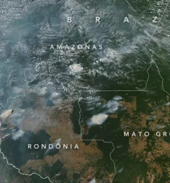
Articles & Stories Applied Sciences Team project informs decision makers with fire season forecast SERVIR AST member Doug Morton discusses the upcoming fire season in Amazonia in a new NASA article. July 11, 2020
Articles & Stories Monitoring air quality from space during the COVID-19 pandemic SERVIR-HKH has developed the Air Quality Explorer for the HKH using freely available satellite data and the Google Earth Engine platform. The application allows visualization of three atmospheric parameters — nitrogen dioxide (NO2), sulphur dioxide (SO2), and Aerosol Optical Depth (AOD) — for any chosen period and location. June 9, 2020
Articles & Stories Knowledge Forum calls for Regional Cooperation on Early Warning for Flood and High-Impact Weather Events The Hindu Kush Himalayan (HKH) region is no stranger to water- and weather-induced hazards. Every year, these disasters result in loss of lives, livelihoods, and damage to infrastructure throughout HKH countries. December 6, 2019
Articles & Stories SERVIR-Amazonia Brings Data to the Ground for Better Decision-Making in the Amazon A blog posted by Spatial Informatics Group (SIG) describes ways that the new SERVIR-Amazonia hub will bring geospatial information to assist with sustainable development problems and natural resource protection for the Amazonia region. March 19, 2019
Articles & Stories USAID and NASA Harnessing Technology for Development in the Amazon The United States Agency for International Development (USAID) and the U.S. National Aeronautics and Space Administration (NASA) announced on March 8 a five-year project that will use satellite imagery to address environment and development challenges across the Amazon Basin. March 12, 2019