Articles & Stories Tracking the Perfect Storm in West Africa: COVID-19 and Desert Locusts 
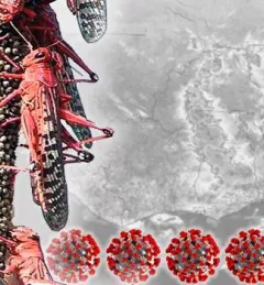
The West Africa region has hard-won experience in managing both desert locust (Schistocerca gregaria, Forskål) outbreaks and outbreaks of serious viral epidemics like Ebola. June 27, 2020
Articles & Stories How the SERVIR program connects space to village The SERVIR program, launched in 2005, connects NASA, U.S. researchers, a network of development partners around the world, and companies like Google to harness the power of satellite observations — helping countries see, with greater clarity, how their environments affect well-being and safety. June 24, 2020
Articles & Stories Monitoring air quality from space during the COVID-19 pandemic SERVIR-HKH has developed the Air Quality Explorer for the HKH using freely available satellite data and the Google Earth Engine platform. The application allows visualization of three atmospheric parameters — nitrogen dioxide (NO2), sulphur dioxide (SO2), and Aerosol Optical Depth (AOD) — for any chosen period and location. June 9, 2020
Articles & Stories SERVIR-Mekong promotes satellite technology to track fire hotspots and monitor air pollution Forest fires have been raging across Northern Thailand for the past month, endangering the lives of animals and people. During the second half of March 2020, a considerable number of fire hotspots were detected within protected forest areas across eight provinces, with the highest concentration in Chiang Mai and Mae Hong Son provinces. June 3, 2020
Articles & Stories Ensuring Resilience for People and Ecosystems Guyana Advances Mangrove Monitoring with Satellite Technology While mangroves ordinarily provide multiple benefits to Guyana's coast, they are currently under threat due to rising sea levels, deforestation, and coastal erosion. June 2, 2020