Articles & Stories
Taking stock of the damage: Mapping the impact of the 2019 Bangladesh floods using satellite imagery
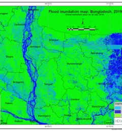
In view of the recent flooding events in South Asia, ICIMOD has prepared flood inundation maps by analysing freely available satellite imagery. These maps provide a synoptic overview of the extent of the inundation caused by the floods and can aid disaster management agencies in prioritizing relief and rescue activities in flood-affected areas.