Articles & Stories Ensuring Resilience for People and Ecosystems Guyana Advances Mangrove Monitoring with Satellite Technology 
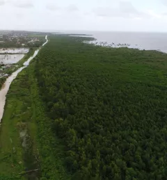
While mangroves ordinarily provide multiple benefits to Guyana's coast, they are currently under threat due to rising sea levels, deforestation, and coastal erosion. June 2, 2020
Articles & Stories Could Satellites Help Head Off a Locust Invasion? A single desert locust can consume its body weight in vegetation in one day. When 40 million of them gather, they can devour as much food as 35,000 people. April 14, 2020
Articles & Stories Reducing illegal gold mining in the tropical forests of Ghana and Peru A forthcoming collaboration across the Atlantic At the recent global knowledge exchange of SERVIR staff from SERVIR-Amazonia and SERVIR-West Africa exchanged ideas and experiences on services for illegal mining detection. April 10, 2020
Articles & Stories Youth tackle air pollution using satellite data As Thailand's second largest city, Chiang Mai has been facing the problem of haze pollution over the past decade, due to agricultural practices and rapid industrial growth associated with tourism. April 9, 2020
Articles & Stories Enhancing Forest Monitoring Across the Lower Mekong and South Asia Using Synthetic Aperture Radar Applications Forests cover approximately 30 percent of Earth's land surface and play a vital role in the global carbon cycle: forests account for around 72 percent of Earth's terrestrial carbon storage, making vegetation biomass a larger carbon store than the atmosphere. March 12, 2020