
Use Case: Greening Prey Lang
SERVIR Mekong use of Collect Earth Online for Greening Prey Lang
SERVIR Hub: SERVIR-Mekong
Geographic Location: Prey Lang Extended Landscape, Cambodia
User Background: Collect Earth Online (CEO) plays a vital role in efforts to protect critical forestland in Cambodia and improve the lives of the people who live there.
Greening Prey Lang, a USAID program created in 2018, works to conserve natural and cultural heritage while improving the livelihoods of rural populations within a large area of northern Cambodia known as the Prey Lang Extended Landscape (PLEL).
SERVIR-Mekong—a joint initiative of USAID and NASA that is implemented by the Asian Disaster Preparedness Center (ADPC)—is using its expertise in remote sensing to help monitor the vast area.
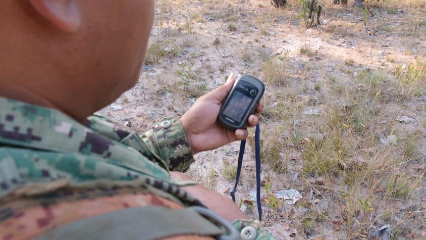
“The Prey Lang Extended Landscape covers over 3.3 million hectares of forests, watersheds, and agricultural land and is affected by illegal logging, deforestation, and unsustainable land use change,” says Ankit Joshi, Senior Technical Specialist at ADPC. “And the Cambodia Ministry of Environment has limited boots on the ground.”
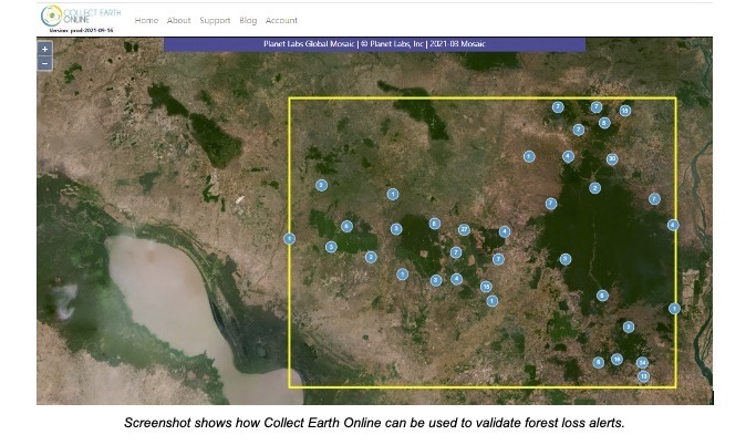
SERVIR-Mekong developed the Cambodia Protected Area Alert System, a satellite-based system that automatically generates alerts when it detects deforestation or other unsustainable land use practices. CEO is used to confirm that these alerts are accurate—that they represent actual forest loss on the ground.
Once the alert is confirmed using CEO, “its exact location—using geographic coordinates—is sent to forest rangers and community patrol teams on the ground for an in-person assessment,” Joshi says. “This enables them to maximize their limited human resources.”
Efficient use of rangers should lead to better enforcement of forest regulations. And that means the region’s landscape will be better protected.
CEO for Prey Lang
The USAID Greening Prey Lang program was designed to conserve Cambodia’s natural and cultural heritage while improving the livelihoods of rural populations. It aims to promote resilient, low-emission, and inclusive management of the Prey Lang Extended Landscape, which protects forests, watersheds, and agricultural land in the provinces of Kampong Thom, Preah Vihear, Stung Treng, and Kratie. The area is home to more than 1 million people.
To monitor its landscapes, the USAID Greening Prey Lang program developed a platform that integrates ground-based and remotely sensed data to assist law enforcement and conservation efforts. A key component of the government platform is the Cambodia Protected Area Alerts System (PAAS) developed by SERVIR-Mekong.
PAAS relies on synthetic aperture radar (SAR) data provided by the European Space Agency’s Sentinel-1 satellites. Unlike optical imagery, this technology can penetrate cloud cover, a crucial ability in a region where the rainy season lasts more than half the year.
The PAAS system’s computer algorithms analyze the SAR data and generate alerts when deforestation or forest degradation is detected. This automatic system, however, sometimes generates false alarms, so it would be inefficient to dispatch law enforcement to the field for every alert.
That’s where Collect Earth Online has proved immensely valuable.
SERVIR-Mekong staff developed a way to use CEO to validate the forest loss alerts. Using high-resolution images available through CEO, they examined the areas for which the alert had been generated to confirm that forest loss had in fact taken place there.
The work relied on collaborative data collection, which is a key feature of CEO. SERVIR-Mekong conducted training sessions to teach employees of the Cambodian government, USAID, Greening Prey Lang, conservation groups, and other non-governmental organizations how to use CEO to validate the forest alerts. In the future, community members within the Prey Lang area will also be involved in the alert validation process.
Key Role for NICFI Planet Imagery
Nguyen Hanh Quyen, Geospatial Service Manager for ADPC, says a number of CEO features made the platform especially useful in the validation work.
She highlighted the high-resolution imagery from Planet, which is available in CEO courtesy of Norway’s International Climate & Forests Initiative (NICFI). The Planet basemaps, with a resolution of less than 5 meters per pixel, are updated roughly every month, providing access to a consistent, date-stamped data source.
Those date stamps are crucial. Previously, the available high-resolution imagery was not time-stamped, and “that was a challenge,” Nguyen says, because enforcement requires knowing when forest loss occurred.
“Now, when our system generates a forest alert, then we can look into the NICFI image of the month before the alert and also the month after the alert to confirm if the alert is correct or not,” Nguyen explains. “If we have the forest alert in August, for example, then we would check the image in July and see if it was forest in July. And then we also check the image in September and see if there is any change on the ground.”
If the NICFI Planet imagery shows forest in July but not in September, then they know the forest loss alert was correct—and rangers are dispatched to the area.
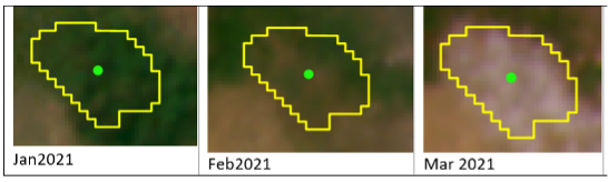
Date-stamped NICFI Planet imagery helps CEO users validate automatically generated forest loss alerts.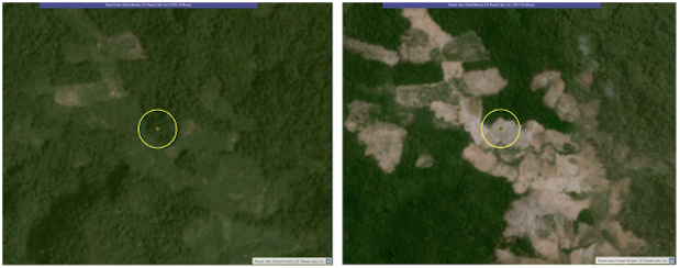
The two images above show the same plot before and after forest clearing.
Another CEO feature, proactive sampling, allows users to draw points, lines, and polygons within a plot. In the Greening Prey Lang project, for instance, data collectors can use the proactive sampling tool to draw a polygon around the confirmed deforested area before forwarding alert information to provincial law enforcement officers.
Other Useful CEO Features
Nguyen also cites a number of other CEO features that have been useful in the work.
“We really like Geo-Dash,” she says, “especially the Forest Degradation Tool.”
That tool helps users verify cases of forest degradation—temporary change in tree canopy cover—by combining the Normalized Difference Fraction Index (NDFI) with a time series of satellite imagery, allowing users to detect even subtle and short-lived changes in the forest canopy.
NDFI expresses what portion of a plot of land is covered by green vegetation as opposed to bare soil or non-photosynthetic (dead or dormant) vegetation.
Having a time series helps avoid confusion between seasonal vegetation patterns and forest degradation. For example, deciduous forests in Cambodia generally will show a higher proportion of non-photosynthetic vegetation during the dry season. If a similar signal appears during the rain season, however, it is more likely to indicate forest degradation. In an evergreen forest, a change in vegetation in any season could indicate degradation.
“For land cover plot validation, Geo-Dash really helps us tell if it is evergreen forest or deciduous forest,” Nguyen says.
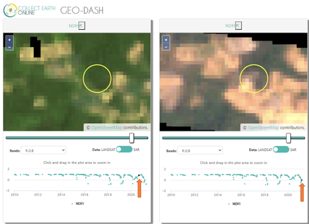
CEO's Geo-Dash has a Forest Degradation Tool that uses NDFI time series, Landsat, and Sentinel SAR data to help users detect forest degradation and deforestation.
She also appreciates that CEO allows her to use private institutional imagery alongside the imagery that is publicly available to all.
“We can add the asset of tree canopy height or tree canopy cover into our image collection,” she explains. “Collect Earth online’s default data set doesn't have that information, but it’s what we need for our validation process.”
The ability to use an existing project as a template for future projects is also helpful.
“Sometimes we need to create a lot of survey questions and use them repeatedly—for different projects, different areas, or different months,” Nguyen says. “Using the previous template has really helped us to duplicate the projects in a very efficient way.”
Real-World Impacts
Deforestation poses a profound problem in Cambodia. The country was 73 percent forested in 1965, but by 2018 that figure had dropped to 47 percent. A recent USAID-funded report found that deforestation in Cambodia is being driven largely by logging, charcoal production, mining, and economic land concessions for commodity crop plantations.
The loss of forest has wide-ranging effects in Cambodia. Beyond increasing greenhouse gas emissions, it also threatens a range of sustainable economic activities such as resin collection, ecotourism, and diversified agriculture.
Ultimately, the goal of the USAID Greening Prey Lang project is to protect landscapes, ecosystems, and the livelihoods of people in the region.
By improving the forest alert system, CEO is helping Cambodia use its limited enforcement resources more efficiently, thereby better protecting forests and the people who rely on them.
“Collect Earth Online has really become a very powerful tool,” Nguyen says.
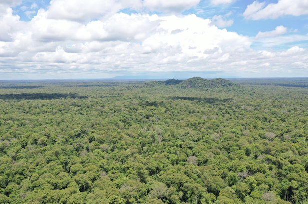
Aerial image of forests in the Greening Prey Lang area. Image courtesy USAID Greening Prey Lang project.