Strategy & Guidance USAID Geospatial Strategy USAID’s 2024-2028 Geospatial Strategy promotes leveraging the power of geospatial data and technology to target the delivery of international programs. November 15, 2023
Infographic SERVIR's Service Approach SERIR uses a "service" approach to identifying and addressing climate challenges. April 17, 2019
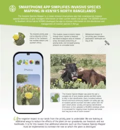
Infographic Kenya Invasive Species Mapper Smartphone app simplified invasive species mapping in Kenya's north rangelands The Invasive Species Mapper is a citizen-science smartphone app that crowdsources invasive species detection to give managers information on their current extent and spread.