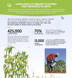
Fact Sheet 
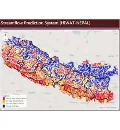
Fact Sheet: Improving Flood Forecasting in the Mekong River 
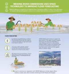
Learn how SERVIR-Mekong is supporting the Mekong River Commission (MRC) in using satellite-derived precipitation products to increase flood forecast accuracy and lead time. December 13, 2020
Infographic Using Satellite Imagery to Expand Crop Insurance in Kenya Through a partnership between SERVIR Eastern & Southern Africa and the Kenya Ministry of Agriculture, a new satellite-based crop mapping system and sampling methodology was developed to streaml October 23, 2020
Use Case Use Case: Vietnam Academy for Water Resources VAWR, which operates under Vietnam’s Ministry of Agriculture and Rural Development (MARD), is the leading institute for water resources, research and development within Vietnam. September 22, 2020
Use Case Use Case: Nepal Department of Hydrology and Meteorology The Nepal DHM is the national agency responsible for monitoring and managing the hydrological resources of Nepal. This Use Case describes how they used the SERVIR Enhancing Flood Early Warning Services (EWS). September 16, 2020
Use Case Use Case: Mekong River Commission The Mekong River Commission (MRC) is an intergovernmental organization that provides coordination and technical input on flood management to the members of the Lower Mekong countries including Cambodia, Lao PDR, Thailand, and Vietnam. August 31, 2020