Video
Regional Drought Monitoring and Early Warning System

SERVIR scientists discuss the how the Regional Drought Monitoring and Early Warning System is being used in the Hindu Kush Himalaya region.

9 results
SERVIR scientists discuss the how the Regional Drought Monitoring and Early Warning System is being used in the Hindu Kush Himalaya region.
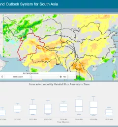
The Regional Drought Monitoring and Outlook System (RDMOS) was developed to help predict, mitigate, and adequately respond to drought vulnerabilities in the HKH region.
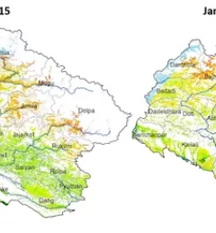
Remote districts of Western Nepal are experiencing what some claim is their worst drought in 40 years. Analyses prepared by the International Center for Integrated Mountain Development are helping the Government of Nepal evaluate the situation and make critical decisions about how to respond.
This collection of case studies is a companion to the SERVIR Service Planning Toolkit. It provides concrete examples from SERVIR’s experience, and that of our partners, applying the Service Planning approach.

The crucial role forests play in our world cannot be underestimated. To enhance preservation and monitoring of this natural resource, SERVIR and SilvaCarbon launched a series of global workshops this year in West Africa, Eastern and Southern Africa, Hindu-Kush Himalaya, and the Lower Mekong region on Synthetic Aperture Radar (SAR) applications.
ICIMOD, ADPC, and CSRD are organizing a three-day Regional Knowledge Forum on Earth Observation and Climate Services for Food Security and Agricultural Decision Making in South and Southeast Asia, 8 – 10 October 2018.

ICIMOD, under its SERVIR-Hindu Kush Himalaya (SERVIR-HKH) and Climate Services for Resilient Development (CSRD) Initiatives, is collaborating with technical organizations in the United States and meteorological and agricultural institutions in the HKH to establish a regional agricultural drought monitoring and early warning system.
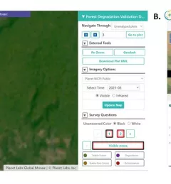
Users of Collect Earth Online (CEO) around the world are taking advantage of a CEO feature called the Geo-Dash Degradation Tool that allows them to monitor forest degradation, a major source of carbon emissions.
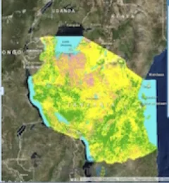
To sustainably manage forest landscapes, governments and decision makers need accurate and up-to-date information on the extent of the forests they manage and the ways they are changing.