Infographic
Commitment to Gender Inclusion
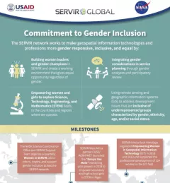
Learn more about how the SERVIR network works to make geospatial information technologies and professions more gender responsive and inclusive.

3 results
Learn more about how the SERVIR network works to make geospatial information technologies and professions more gender responsive and inclusive.
Collect Earth Online is a custom built, open-source, satellite image viewing and interpretation system developed by SERVIR, FAO, and other partners as a tool for use in projects that require land cover and/or land use data.
According to the World Wildlife Fund, over 2 billion people rely on forests for shelter, livelihoods, water, food, and fuel security. Forests even help renew our air supply, as they take in large amounts of carbon dioxide and release oxygen.