Laos dam collapse and flooding: View from Space
The collapse, on the night of July 23, of the Xe Namnoy Xe Pian Dam in Sanamxay district, Attapeu province of Lao PDR, flooded villages and left thousands homeless.
6 results
The collapse, on the night of July 23, of the Xe Namnoy Xe Pian Dam in Sanamxay district, Attapeu province of Lao PDR, flooded villages and left thousands homeless.
A NASA Goddard Space Flight Center (GSFC) News Feature describes how a new tool provided local authorities and decision-makers in Laos with near real-time information to assess damages and provide help following the July 23 failure of a hydropower dam.
SERVIR hubs are at the forefront in developing high-quality water information, tools, products, and services that enable partner countries to monitor, measure, and report on water resources and changes, and to better predict and manage water-related disasters.
Lower Mekong countries suffer from the effects of seasonal flooding and flash flooding caused by monsoon rains and tropical storms. Regional and national level organizations and agencies require a range of information, forecasts, and decision-support tools to better prepare for, monitor, issue warnings, and respond to flood risk.
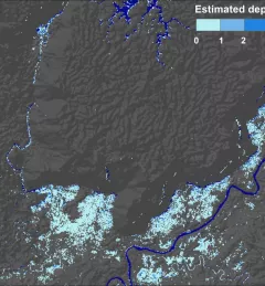
Enhancing Anticipatory Actions for Disaster and Climate Resilience aims to reduce the loss of lives and damage to properties and crops from floods and droughts by improving early warnings using satellite data and geospatial information.
The Supporting Better Riverine and Flash Flood Forecasting for the Lower Mekong service improves riverine flood forecasts and enhances flash flood guidance monitoring in the region.