Tool
SERVIR Service Planning Toolkit
The Service Planning Toolkit is a resource for SERVIR Hubs and their partners to implement SERVIR's service planning approach.

211 results
The Service Planning Toolkit is a resource for SERVIR Hubs and their partners to implement SERVIR's service planning approach.
As part of this service, SERVIR HKH, with the technical support of Brigham Young University developed a streamflow prediction tool that incorporates all primary and secondary rivers in the HKH region

The service, Building a Dashboard to Monitor, Evaluate and Report Landscape Improvements in Cambodia, addresses the demand from USAID/Cambodia to monitor and evaluate projects that target biophysical improvement and enhance biodiversity conservation on the ground.
The Development and Management of Groundwater Analysis and Information System in Niger is a platform to improve and make available information on groundwater in Mar
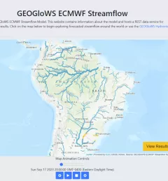
The Improving Resilience and Reducing Risk of Extreme Hydrological Events service provides stakeholders in the Amazon Basin region with improved historical water information and a flood forecasting ability to support greater resiliency to flood disasters.

Through the Improving the Mekong River Commission's (MRC) Regional Flood Forecasting Service, SERVIR Mekong supported the MRC to use new-generation satellite-derived precipitation products to increase flood forecast accuracy.
The Increased Capacity and Public Access to the Ministry of Environment (MOE) Geospatial Data Portal service supported the Cambodia MOE’s sustainable landscape initiatives by increasing public access to its Environmental Data Portal.

The service, Increased Capacity of NGOs and Educational Institutions to use Remote Sensing to Monitor Forest Cover and Landscape Management, increased technical capacity and provided technical assistance to select partners working to monitor and protect land and forest resources in Cambodia.
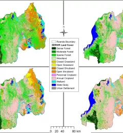
The Land Use Land Cover and Change Mapping Service was designed to provide governments with data, tools, and skills to better understand relevant intervention actions related to land conservation and management, ensuring that land resources can be efficiently monitored and regulated.
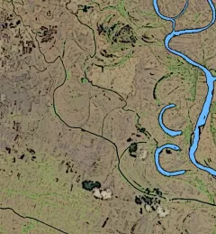
The Mitigating Impacts and Increasing Benefits from Changing River Courses in Myanmar service supported national agencies in monitoring changing river courses and planning riverbank protection measures to mitigate localized impacts to infrastructure.