Strategy & Guidance
USAID Geospatial Strategy

USAID’s 2024-2028 Geospatial Strategy promotes leveraging the power of geospatial data and technology to target the delivery of international programs.

4 results
USAID’s 2024-2028 Geospatial Strategy promotes leveraging the power of geospatial data and technology to target the delivery of international programs.
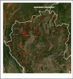
Forest fires have been raging across Northern Thailand for the past month, endangering the lives of animals and people. During the second half of March 2020, a considerable number of fire hotspots were detected within protected forest areas across eight provinces, with the highest concentration in Chiang Mai and Mae Hong Son provinces.
SERVIR Hindu Kush Himalaya partnered with the University of Alaska Fairbanks to organize a training titled HydroSAR: Extracting flood information from SAR to advance the use of SAR at ICIMOD and across the HKH region.

SERVIR will be at the American Geophysical Union conference in San Francisco, December 11 - 15, 2023. Please come and meet us at our talks and posters.