
Flash Flood Vulnerability Mapping in West Africa
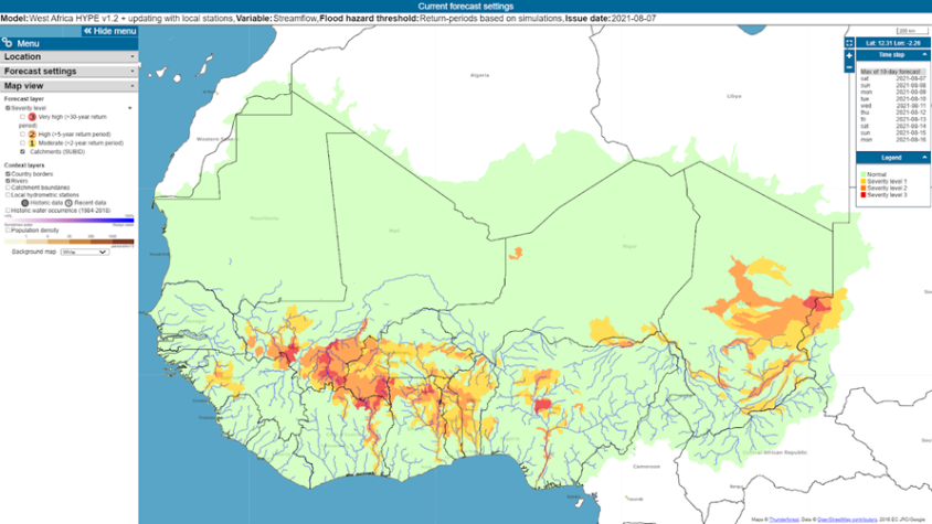
ReinForced cooperAtion to provide operatioNal Flood forecasting and Alerts in West afRica (FANFAR) is an ongoing effort implemented by the Swedish Meteorological and Hydrological Institute and AGRHYMET. The SERVIR West Africa program will leverage this effort by integrating relevant, granular, and up-to-date socioeconomic data layers, and making them available to improve flash flood vulnerability mapping and early assessments of the potential socioeconomic impacts of anticipated floods. The Flash Flood Vulnerability Mapping service will focus on improving FANFAR's ability to translate hydrological model outputs into meaningful predictions of socioeconomic impact and to generate alerts. Additionally, SERVIR West Africa will strengthen users’ capacity to mitigate flash flood risks by piloting appropriate hydrological model prototypes in selected small catchments, supported by locally validated, high-resolution population, infrastructure, crop, topographic, and climate data. Test catchments will be selected based on the availability of data and historical flash flood events.
Rationale
Extreme meteorological and hydrological phenomena have become in recent years so recurrent and severe that they hamper the development of countries in the West African sub-region. The risk of extreme events including floods and their potential impacts are not properly taken into account by the operational warning platforms in the region. Predicting these phenomena makes it possible to mitigate their effects by taking adequate anticipatory measures. Therefore, AGRHYMET will provide timely information for the end users to adapt to and mitigate these extreme events. The service will involve two components and deployment stages:
- The incorporation of socioeconomic data into the existing FANFAR consortium platform coordinated by the Swedish Meteorological and Hydrological Institute and AGRHYMET
- The development of small catchment-scale “living labs” to learn how to support local adoption and co-ownership of flash flood mitigation services, based on community interactions around best available high-resolution socioeconomic and DEM data, combined with locally calibrated and validated hydrological models.
-
Users
IGOs
Basin organization
Ministries of Water Resources
Hydraulic works managers
Humanitarians
NGOs and Associations
Projects and programs
Universities and Research Centers
Local authorities and communities
-
Training Materials