
Locally Led Development Drives Climate Action at the SERVIR Mekong Hub
The SERVIR Mekong hub is based at the Asian Disaster Preparedness Center (ADPC) in Bangkok, Thailand1. ADPC is an autonomous international organization that works to build the resilience of people and institutions to the impacts of disasters and climate change in Asia and the Pacific. The hub operates in Burma (Myanmar), Cambodia, Lao PDR, Thailand, and Vietnam. The majority of the hub’s work is with the Mekong River Commission, a treaty-based regional intergovernmental organization that is made up of Mekong countries.
SERVIR Mekong is supported by three consortium partners, including:
- Spatial Informatics Group (SIG), based in California
- Stockholm Environment Institute (SEI), based in Thailand
- Deltares, based in The Netherlands
SERVIR Mekong aligns with the U.S. Indo-Pacific Vision of “a free and open Indo-Pacific that is more connected, prosperous, secure and resilient.” The hub works with USAID’s Regional Development Mission for Asia (RDMA), USAID bilateral missions, and reputable NGOs to help realize this vision. SERVIR Mekong uses geospatial data to enhance climate change adaptation and help address the regional challenge of managing shared natural resources.
SERVIR Mekong co-develops regional geospatial tools and services ranging from drought monitoring, flood forecasting, and crop yield management to improve natural resources management and environmental conservation and protection in line with the Mekong-U.S. Partnership. The Partnership, launched in 2020, promotes the stability, peace, prosperity, and sustainable development of the Mekong sub-region through cooperation in addressing transboundary challenges among Mekong countries with support from the United States.
On October 26, 2021, during the U.S.-ASEAN Summit, President Biden announced that he would expand the U.S.-ASEAN Strategic Partnership, providing up to $102 million for new initiatives to ensure a free and open Indo-Pacific. According to the White House Fact Sheet, the United States intends to provide up to $20.5 million for a new U.S.-ASEAN Climate Futures initiative dedicated to tackling the climate crisis and keeping the urgent goal of limiting global warming to 1.5 degrees Celsius within reach. SERVIR Mekong is listed as one of the activities that can support the U.S.-ASEAN Climate Futures initiative by harnessing remote sensing technology and open data to help address development challenges related to a changing climate. SERVIR Mekong’s tools and services can support ASEAN countries, prepare for and respond to droughts and floods, support sustainable management of natural landscapes, and increase uptake of nature-based solutions for enhanced climate resilience.
Below are a few examples of how SERVIR’s Mekong hub is working with local governments and communities to manage challenges – in areas of food security, water resources, weather and climate, land use, disasters, and air quality – that are made increasingly more difficult by a changing climate.
Empowering Local Communities to Manage Forest Fires Using the Air Quality Explorer Tool
In Thailand, data from SERVIR Mekong’s Air Quality Explorer instrument is giving first responders and local governments in fire-prone communities the data and tools they need to more effectively manage forest fires. Dr. Nion Sirimongkonlertkul and her team from Rajamangala University of Technology (Thailand) developed the SmokeWatch App that is used by officials to monitor and manage forest fires in the Chiang Rai Province in Northern Thailand. The Smoke Watch App, which uses data from SERVIR Mekong’s Air Quality Explorer tool to pinpoint forest fires in near real-time, was recently awarded the National Innovation Award 2021, by the Government of Thailand.
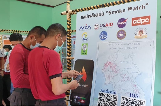
First responders in Thailand's Chiang Rai Province learn how to use the Smoke Watch App
to use data from SERVIR Mekong's Air Quality Explorer tool to pinpoint forest fires in near
real-time. Photo credit: Dr. Nion Sirimongkonlertkul and Fulfill Social Enterprise, Thailand
Enhancing Drought Resilience and Improving Food Security through the Drought and Crop Watch Tool
In Vietnam, SERVIR Mekong co-developed the Drought and Crop Watch Tool with the Vietnam Academy for Water Resources (VAWR) to enhance drought resilience and improve food security. VAWR is a technical agency under Vietnam’s Ministry of Agriculture and Rural Development. This co-development with VAWR builds upon the success of SERVIR Mekong’s drought service at the regional level with the Mekong River Commission. VAWR uses the Drought and Crop Watch tool to use monthly drought bulletins to effectively communicate drought forecasts in Vietnam’s Ninh Thuan province up to three months in advance. Effective response to drought forecasting during both emergencies and routine operations promotes food security and economic prosperity in Vietnam.
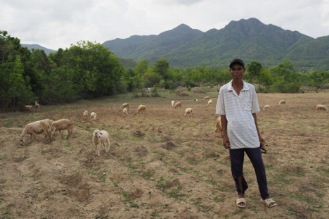
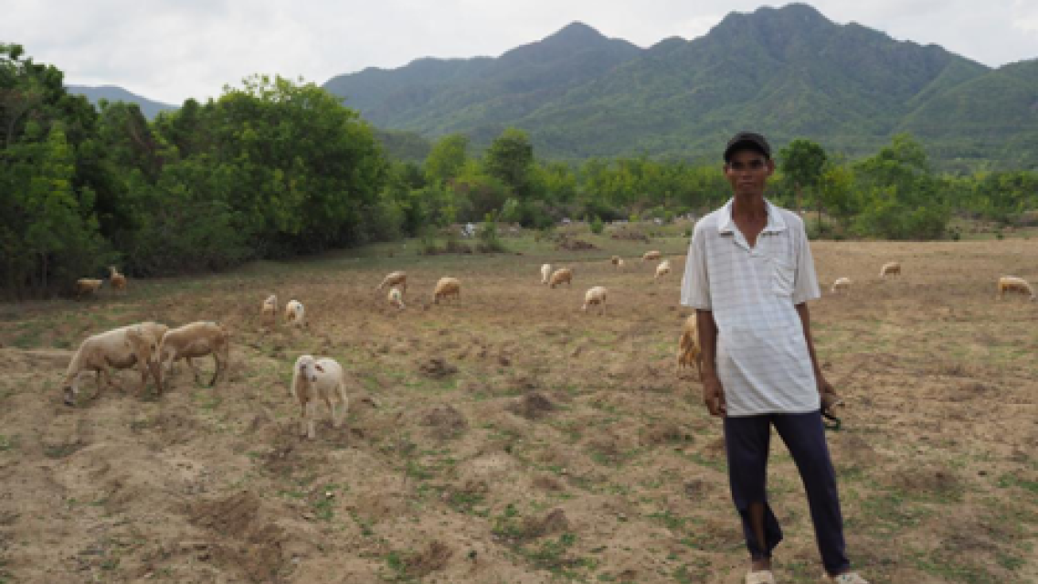
A farmer grazes his sheep in Vietnam's drought-prone Ninh Thuan province.
Photo credit: Asian Disaster Preparedness Center, Thailand
Supporting the USAID Greening Prey Lang Project and Wildlife Conservation Society in Cambodia
In Cambodia, SERVIR Mekong worked with the USAID Greening Prey Lang project and the Wildlife Conservation Society, Cambodia (WCS) to co-develop and implement the Cambodia Protected Area Alerts System (Forest Alert Tool). These co-development partners provided SERVIR Mekong with deforestation data to train machine learning models to spot deforestation and also validate the forest alerts using forest patrols to ensure accuracy. SERVIR Mekong’s Forest Alert Tool is designed to monitor near real-time forest changes and external threats such as forest fires within the Prey Lang Extended Landscape in Cambodia. Forest officials and community patrol teams use this information to prioritize their scarce resources for more efficient patrol planning and better protection of the 6.2-million-hectares Prey Lang extended landscape.
Through the combined efforts of regional hubs, and with technical support from USAID, NASA, and U.S.- based science collaborators, SERVIR has been front and center at promoting locally led development and climate action around the world. The SERVIR Global network demonstrates the value of Earth Observation and collaborative science and is strategically placed to support these new climate initiatives of the U.S. government and USAID. To learn more about how SERVIR’s locally led development is driving climate action across its five hubs, click here.
1A joint initiative of NASA and USAID, SERVIR works in partnership with leading regional organizations worldwide to help developing countries use information provided by Earth observing satellites and Earth science to address development challenges in food security, water resources, weather and climate, land use, disasters, and air quality.
