Articles & Stories NASA feature highlights Applied Sciences Team monitoring drought in Eastern Africa 
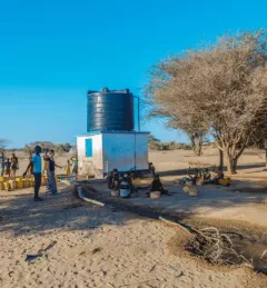
A recent NASA article highlighted Applied Sciences Team Principal Investigator Dr. Evan Thomas and the Drought Resilience Impact Platform (DRIP). March 3, 2021
Articles & Stories SERVIR Flood Mapping Service Brings Speed to Cambodia Disaster Management The new Hydrologic Remote Sensing Analysis for Floods (HYDRAFloods) service, co-developed by SERVIR-Mekong consortium members and the SERVIR Science Coordination Office, improves the frequency and resolution of map updates. January 30, 2021
Articles & Stories Serving Governments' Climate Data Needs SERVIR's service planning approach brings partners, stakeholders, and end users into the design process from the very beginning, even before solutions are discussed. October 1, 2019
Articles & Stories Mekong River Commission Utilizes Space Technology to Improve Flood Forecasting Lower Mekong countries suffer from the effects of seasonal flooding and flash flooding caused by monsoon rains and tropical storms. Regional and national level organizations and agencies require a range of information, forecasts, and decision-support tools to better prepare for, monitor, issue warnings, and respond to flood risk. August 8, 2019
Articles & Stories SERVIR-Amazonia Brings Data to the Ground for Better Decision-Making in the Amazon A blog posted by Spatial Informatics Group (SIG) describes ways that the new SERVIR-Amazonia hub will bring geospatial information to assist with sustainable development problems and natural resource protection for the Amazonia region. March 19, 2019