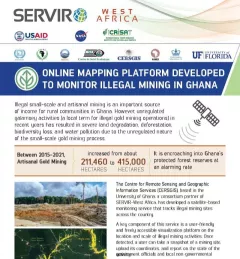
Fact Sheet Fact Sheet: Online Mapping to Fight Illegal Mining in Ghana This fact sheet highlights efforts to monitor illegal mining in Ghana. December 23, 2020
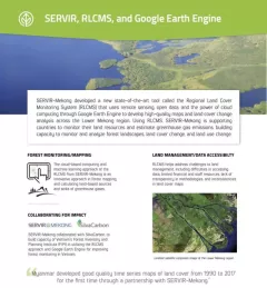
Fact Sheet Fact Sheet: Regional Land Cover Monitoring System SERVIR, RLCMS, and Google Earth Engine SERVIR-Mekong developed a new state-of-the-art tool called the Regional Land Cover Monitoring System (RLCMS) to develop high-quality maps and land cover change analysis across the Lower Mekong region. December 13, 2020
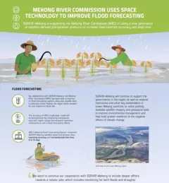
Fact Sheet Fact Sheet: Improving Flood Forecasting in the Mekong River Learn how SERVIR-Mekong is supporting the Mekong River Commission (MRC) in using satellite-derived precipitation products to increase flood forecast accuracy and lead time. December 13, 2020
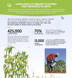
Infographic Using Satellite Imagery to Expand Crop Insurance in Kenya Through a partnership between SERVIR Eastern & Southern Africa and the Kenya Ministry of Agriculture, a new satellite-based crop mapping system and sampling methodology was developed to streaml October 23, 2020