Strategy & Guidance USAID Geospatial Strategy USAID’s 2024-2028 Geospatial Strategy promotes leveraging the power of geospatial data and technology to target the delivery of international programs. November 15, 2023
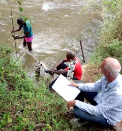
Use Case Use Case: E-link Consult Limited E-link Consult Limited worked with SERVIR E&SA to assist the WARIDI program in climate vulnerability analysis for programming interventions in Tanzania. November 20, 2021
Report SERVIR Service Planning in Action Case Studies from Demand-Driven Geospatial Services This collection of case studies is a companion to the SERVIR Service Planning Toolkit. It provides concrete examples of SERVIR's Service Planning approach. May 5, 2021
Training Mapping and Monitoring Mangroves using Google Earth Engine A Virtual Workshop hosted by SERVIR Amazonia This workshop is the third in a series offered by SERVIR Amazonia focused on using remote sensing to monitor mangroves in Guyana. December 15, 2020
Strategy & Guidance SERVIR Strategic Plan 2020-2025 This strategic plan identifies the next set of cross-cutting strategic priorities that will ensure SERVIR remains responsive to both NASA and USAID Agency goals and those of stakeholders and users in SERVIR regions. October 10, 2020