Video
Regional Drought Monitoring and Early Warning System

SERVIR scientists discuss the how the Regional Drought Monitoring and Early Warning System is being used in the Hindu Kush Himalaya region.

11 results
SERVIR scientists discuss the how the Regional Drought Monitoring and Early Warning System is being used in the Hindu Kush Himalaya region.
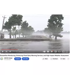
The Nepal DHM is the national agency responsible for monitoring and managing the hydrological resources of Nepal. This Use Case describes how they used the SERVIR Enhancing Flood Early Warning Services (EWS).
The Monitoring Extreme Weather in the Hindu Kush Himalaya (HKH) service provides a customized numerical weather prediction toolkit to assess high impact convective weather events over the HKH region.
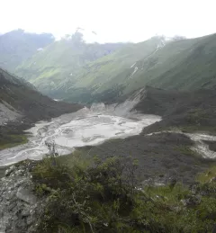
On 28 June 2015, around 7 pm local time, a yak herder in Bhutan witnessed an alarming spectacle: a glacial lake outburst flood, or GLOF. He looked on as water from Lemthang Tsho (Memari) Lake, which had filled beyond capacity, burst over its embankment.
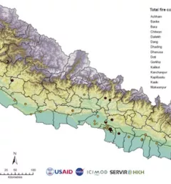
Forest fires have adverse ecological and economic effects and are a major concern in many countries, including Nepal. During the long, dry summers, Nepal experiences many forest fires. In 2016, a record number of fires were reported killing 15 people and consuming an area of 13,000 square kilometers (1.3 hectares) in the span of just two weeks.
The Hindu Kush Himalayan (HKH) region is no stranger to water- and weather-induced hazards. Every year, these disasters result in loss of lives, livelihoods, and damage to infrastructure throughout HKH countries.
SERVIR Hindu Kush Himalaya partnered with the University of Alaska Fairbanks to organize a training titled HydroSAR: Extracting flood information from SAR to advance the use of SAR at ICIMOD and across the HKH region.

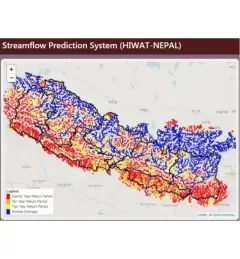
As part of this service, SERVIR HKH, with the technical support of Brigham Young University developed a streamflow prediction tool that incorporates all primary and secondary rivers in the HKH region
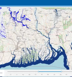
Floods are a recurring event in the HKH region that often have disastrous consequences. To help better understand these events, SERVIR HKH developed the Flood Inundation Mapping Tool, a cloud-based system developed to map flood areas in Bhutan, Bangladesh, Nepal, and the northeast part of India.