Tool
SERVIR Service Planning Toolkit
The Service Planning Toolkit is a resource for SERVIR Hubs and their partners to implement SERVIR's service planning approach.

74 results
The Service Planning Toolkit is a resource for SERVIR Hubs and their partners to implement SERVIR's service planning approach.
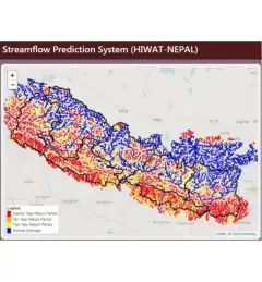
The Nepal DHM is the national agency responsible for monitoring and managing the hydrological resources of Nepal. This Use Case describes how they used the SERVIR Enhancing Flood Early Warning Services (EWS).

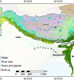
As part of this service, SERVIR HKH, with the technical support of Brigham Young University developed a streamflow prediction tool that incorporates all primary and secondary rivers in the HKH region
Collect Earth Online is a custom built, open-source, satellite image viewing and interpretation system developed by SERVIR, FAO, and other partners as a tool for use in projects that require land cover and/or land use data.
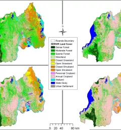
The Land Use Land Cover and Change Mapping Service was designed to provide governments with data, tools, and skills to better understand relevant intervention actions related to land conservation and management, ensuring that land resources can be efficiently monitored and regulated.
The Monitoring Extreme Weather in the Hindu Kush Himalaya (HKH) service provides a customized numerical weather prediction toolkit to assess high impact convective weather events over the HKH region.

The Regional Cropland Assessment and Monitoring Service seeks to provide timely information for food security assessments through the development of national and regional crop monitors in East Africa.
SERVIR-HKH has developed land cover monitoring systems with a modular architecture built on the Google Earth Engine (GEE) computational platform.

The Regional Stream Flow Monitoring and Forecasting Service was designed to provide real-time streamflow forecasts for several watersheds in East Africa and bias-corrected satellite precipitation products to enable the timely prediction and monitoring of extreme events.