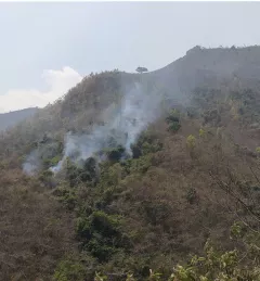
A Steep Climb to Cleaner Air in South Asia
NASA atmospheric scientists and the SERVIR program are working to help keep communities breathing easy in the Hindu Kush and Himalayan mountain ranges.
81 results
NASA atmospheric scientists and the SERVIR program are working to help keep communities breathing easy in the Hindu Kush and Himalayan mountain ranges.
This service improves air quality monitoring through a web-based dashboard that was developed that utilizes publicly available observation data, satellite-based remote sensing products, and atmospheric models.
The Agro-met Advisory Service for National/Local level Planning in Nepal and Bangladesh integrates weather and climate data with information about agriculture practices to provide data analysis support to the professionals responsible for developing agro-met advisory services for government structures and farmers.
The Resilient Forest Management in Nepal is designed to assess the current state of forest ecosystems, identify the drivers of change, and explore suitable adaptation and mitigation measures.
In the low-lying Terai region of Nepal, fields of emerald green rice sweep across the landscape as far as the eye can see. Villages dot the region, which produces the majority of Nepal’s rice.
|Meryl Kruskopf and Jacob Ramthun, SERVIR Science Coordination Office
This service is the outcome of a discussion held during the 2018 West Africa Regional Conference on Land Cover Land Use, at which SERVIR West Africa established the West Africa Land Cover Task Force.
The Flash Flood Vulnerability Mapping service focuses on improving flash flood vulnerability mapping and early assessments of the potential socioeconomic impacts of anticipated floods.
Between January 1st and June 16, 2023, Nepal experienced 118% more forest fires than it had in all of 2022.
The Enabling Sustainable Landscape-Scale Agricultural Management through Fire and Air Quality Monitoring service guides authorities to regulate agriculture burning and manage forest fires using the Mekong Air Quality Explorer Tool.
The Geospatial Applications for Food Security and Sustainable Landscapes service aims to improve food security in Burma (Myanmar) by improving crop planning and forest landscape management practices in the country.