Fact Sheet
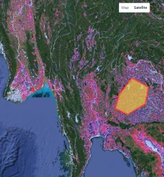
Factsheet: Mekong Regional Land Cover Monitoring System (RLCMS)
SERVIR, RLCMS, and Google Earth Engine

3 results

The Supporting Better Riverine and Flash Flood Forecasting for the Lower Mekong service improves riverine flood forecasts and enhances flash flood guidance monitoring in the region.
Through the Supporting Flood Emergency Preparedness for Myanmar Service, SERVIR Mekong co-developed and supported the use of a systematic decision-support tool for the Myanmar Department of Disaster Management to identify areas with high flood risk.