Strategy & Guidance
USAID Geospatial Strategy

USAID’s 2024-2028 Geospatial Strategy promotes leveraging the power of geospatial data and technology to target the delivery of international programs.

9 results
USAID’s 2024-2028 Geospatial Strategy promotes leveraging the power of geospatial data and technology to target the delivery of international programs.

ClimateSERV is a web-accessible system that allows users to access, visualize, and analyze historical Earth observations useful to decision-making across multiple sectors.

This Gender Analysis Tool provides clear guidance on a foundational step for service design and programming, to contribute to SERVIR’s goals of ensuring that women, along with men, are realizing equal benefits from SERVIR’s geospatial services.
This strategic plan identifies the next set of cross-cutting strategic priorities that will ensure SERVIR remains responsive to both NASA and USAID Agency goals and those of stakeholders and users in SERVIR regions.
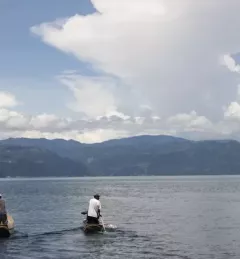
Nestled in between soaring green mountains, Guatemala’s Lake Atitlán is renowned as one of the most beautiful lakes in the world. It has also been under threat by massive blooms of algae clotting its pristine waters. In 2009 and 2015, massive “blooms” of algae threatened to cause severe ecological damage.
|Jacob Ramthun, SERVIR Science Coordination Office
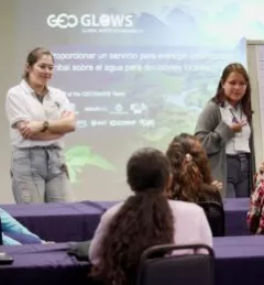
Because climate change disproportionately impacts women and girls, Earth science cannot be fully effective in addressing climate issues without including the realities and unique knowledge of women. Unfortunately, many women are excluded from participating in both the field of Earth science and in community decision-making.
|Lena Pransky, NASA Science Coordination Office
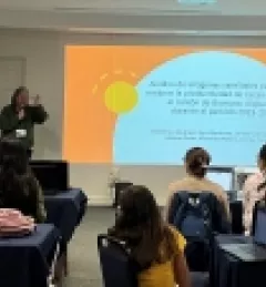
In Costa Rica, the GeoFem workshops create a supportive environment for women to combine their unique knowledge and experiences with Earth science technology. The following stories demonstrate how everyone benefits when women are empowered to use Earth science in community decision-making.
|Lena Pransky, NASA Science Coordination Office

SERVIR improves local and regional capacity to provide tools, products, and services that empower decision makers to better address critical issues related to food security, water resources, natural disasters, land use, and extreme weather. Building on thirteen years of experience, SERVIR has grown in its geographical reach and has adapted its approach based on lessons learned.
The Service Planning Toolkit is a resource for SERVIR Hubs and their partners to implement SERVIR's service planning approach.