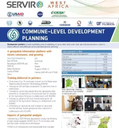
Fact Sheet: Mapping SDGs in West Africa
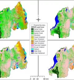
This fact sheet highlights the service, Building a Platform to Track Progress on SDGs and Inform Decisions in Senegal.
112 results
This fact sheet highlights the service, Building a Platform to Track Progress on SDGs and Inform Decisions in Senegal.
This fact sheet highlights how SERVIR West Africa is supporting sustainable management in Burkina Faso through commune-level development planning.
ClimateSERV is a web-accessible system that allows users to access, visualize, and analyze historical Earth observations useful to decision-making across multiple sectors.
This Gender Analysis Tool provides clear guidance on a foundational step for service design and programming, to contribute to SERVIR’s goals of ensuring that women, along with men, are realizing equal benefits from SERVIR’s geospatial services.
This strategic plan identifies the next set of cross-cutting strategic priorities that will ensure SERVIR remains responsive to both NASA and USAID Agency goals and those of stakeholders and users in SERVIR regions.
The service, Building a Dashboard to Monitor, Evaluate and Report Landscape Improvements in Cambodia, addresses the demand from USAID/Cambodia to monitor and evaluate projects that target biophysical improvement and enhance biodiversity conservation on the ground.
The Increased Capacity and Public Access to the Ministry of Environment (MOE) Geospatial Data Portal service supported the Cambodia MOE’s sustainable landscape initiatives by increasing public access to its Environmental Data Portal.
The service, Increased Capacity of NGOs and Educational Institutions to use Remote Sensing to Monitor Forest Cover and Landscape Management, increased technical capacity and provided technical assistance to select partners working to monitor and protect land and forest resources in Cambodia.
The Land Use Land Cover and Change Mapping Service was designed to provide governments with data, tools, and skills to better understand relevant intervention actions related to land conservation and management, ensuring that land resources can be efficiently monitored and regulated.
The Rangeland Assessment and Monitoring Service facilitates the near real-time assessment and monitoring of rangeland resources by developing a web-based tool to aggregate key indicators of rangeland productivity.