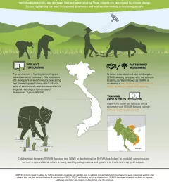
Seasonal water outlook and implications for farmers in the Indus basin
The cryosphere — snow, ice, and permafrost — is an important source of water in the Hindu Kush Himalaya.
|Faisal M. Qamer and Sher Muhammad, SERVIR HKH/ICIMOD
59 results
The cryosphere — snow, ice, and permafrost — is an important source of water in the Hindu Kush Himalaya.
|Faisal M. Qamer and Sher Muhammad, SERVIR HKH/ICIMOD
From April 22 to 29th, SERVIR, the U.S. Space and Rocket Center, and the University of Alabama in Huntsville welcomed a delegation of Thai students and educators to Huntsville, Alabama for a week-long visit aimed at deepening the Discover Thailand's Astronauts Scholarship Program and U.S.-Thailand space collaborations.
Earlier this year, SERVIR welcomed two virtual interns from the University of Twente's International Institute for Geo-Information Science and Earth Observation in Enschede, the Netherlands. The program, better known as ITC, is one of the world's leading geospatial education programs and is known for attracting students from around the world.
NASA atmospheric scientists and the SERVIR program are working to help keep communities breathing easy in the Hindu Kush and Himalayan mountain ranges.
Droughts in the Lower Mekong region cause significant environmental and economic impacts, including loss in agricultural productivity and decreased food and water security.
Air Quality Monitoring for Sustainable Landscapes and Better Human Health aims to reduce greenhouse gas emissions, improve climate resilience and promote better human health by using air quality data for informing and regulating the management of agricultural burning.
This dry season, communities in the central and northern Amazon face increased fire risk linked to El Niño. With the support of SERVIR, decision-makers can more easily track and respond to these fires.
|Lena Pransky and Jacob Ramthun, NASA Science Coordination Office
SERVIR scientists discuss the how the Regional Drought Monitoring and Early Warning System is being used in the Hindu Kush Himalaya region.
Enhancing Anticipatory Actions for Disaster and Climate Resilience aims to reduce the loss of lives and damage to properties and crops from floods and droughts by improving early warnings using satellite data and geospatial information.
The GeoFem: Women in Geospatial Technologies workshop was hosted and organized by the Inter-American Institute for Cooperation on Agriculture (IICA) and the Central America Aerospace Network (RAC) in San José.
|Lena Pransky, NASA Science Coordination Office