Strategy & Guidance
USAID Geospatial Strategy

USAID’s 2024-2028 Geospatial Strategy promotes leveraging the power of geospatial data and technology to target the delivery of international programs.

5 results
USAID’s 2024-2028 Geospatial Strategy promotes leveraging the power of geospatial data and technology to target the delivery of international programs.

SERVIR will be at the American Geophysical Union (AGU) fall conference December 11 - 15, 2023. We have compiled a list of SERVIR affiliated colleagues who will be presenting throughout the week. Please come and meet us at our talks and posters.
Enhancing Flood Early Warning Services aims to build the resilience of vulnerable communities in the Hindu Kush Himalayan region by increasing flood forecast lead times that are hosted on an interactive web platform.
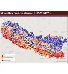
The Nepal DHM is the national agency responsible for monitoring and managing the hydrological resources of Nepal. This Use Case describes how they used the SERVIR Enhancing Flood Early Warning Services (EWS).
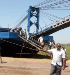
The Regional Stream Flow Monitoring and Forecasting Service was designed to provide real-time streamflow forecasts for several watersheds in East Africa and bias-corrected satellite precipitation products to enable the timely prediction and monitoring of extreme events.