Articles & Stories Science Magazine online article describes survey and assessment of Gorkha earthquake geohazards 
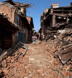
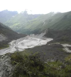
A research article published in Science Magazine's online edition describes survey, mapping and analysis of Nepal's Gorkha earthquake. December 29, 2015
Articles & Stories Investigating Lemthang Tsho (Lake) outburst in Bhutan On 28 June 2015, around 7 pm local time, a yak herder in Bhutan witnessed an alarming spectacle: a glacial lake outburst flood, or GLOF. He looked on as water from Lemthang Tsho (Memari) Lake, which had filled beyond capacity, burst over its embankment. August 26, 2015
Blog SERVIR-Himalaya partner organization earns Humanitarian Award The International Centre for Integrated Mountain Development (ICIMOD), the SERVIR-Himalaya host organization, earned the Esri Humanitarian GIS Award on 20 July 2015 for their contribution to the Nepalese government's disaster response efforts following the recent earthquakes in the country. July 24, 2015
Blog SERVIR small scale applications and small grants promise large impact Working in developing countries around the world, SERVIR seeks to incorporate regional knowledge and perspectives to best meet end user needs in addressing issues such as flood forecasting, forest fire management, landslide hazard, agricultural monitoring, and biomass estimation. July 22, 2015
Blog Earth Observatory features landslide mapping by world-wide agencies in aftermath of Gorkha earthquake After the 7.8 magnitude earthquake in the Gorkha area of Nepal and the ensuing aftershocks, a secondary hazard is looming throughout the surrounding area: landslides. June 8, 2015