Articles & Stories
Using open-source remote sensing data and tools to monitor forest carbon in Bangladesh
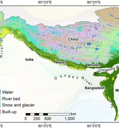
SAR can effectively measure and monitor forest biomass and forest carbon at national scales, particularly in tropical regions.

![SHUKLA_Shrad_photo[1].jpeg](/sites/default/files/styles/card_flag/public/article/image/SERVIR-HKH_thematic_illustration.jpg.webp?itok=isSkllDk)