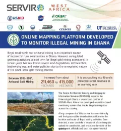
Fact Sheet Fact Sheet: Online Mapping to Fight Illegal Mining in Ghana This fact sheet highlights efforts to monitor illegal mining in Ghana. December 23, 2020
Training Mapping and Monitoring Mangroves using Google Earth Engine A Virtual Workshop hosted by SERVIR Amazonia This workshop is the third in a series offered by SERVIR Amazonia focused on using remote sensing to monitor mangroves in Guyana. December 15, 2020
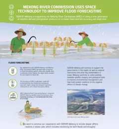
Fact Sheet Fact Sheet: Improving Flood Forecasting in the Mekong River Learn how SERVIR-Mekong is supporting the Mekong River Commission (MRC) in using satellite-derived precipitation products to increase flood forecast accuracy and lead time. December 13, 2020
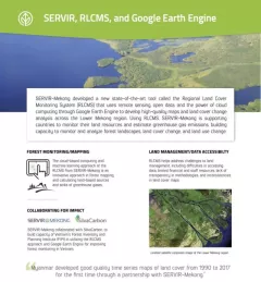
Fact Sheet Fact Sheet: Regional Land Cover Monitoring System SERVIR, RLCMS, and Google Earth Engine SERVIR-Mekong developed a new state-of-the-art tool called the Regional Land Cover Monitoring System (RLCMS) to develop high-quality maps and land cover change analysis across the Lower Mekong region. December 13, 2020
Training Estimating Forest Stand Height (FSH) with Synthetic Aperture Radar (SAR) Synthetic Aperture Radar (SAR) is a useful technology for monitoring forests and estimating biomass since it provides information complementary to optical sensors, such as vegetation structur March 5, 2020